
邵武市 topographic map
Interactive map
Click on the map to display elevation.
About this map
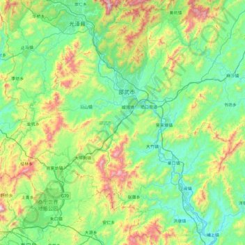
Name: 邵武市 topographic map, elevation, terrain.
Location: 邵武市, 南平市, 福建省, 中国 (26.92349 117.03858 27.58883 117.83448)
Average elevation: 480 m
Minimum elevation: 127 m
Maximum elevation: 1,632 m
Other topographic maps
Click on a map to view its topography, its elevation and its terrain.