
Nova Scotia topographic map
Interactive map
Click on the map to display elevation.
Nova Scotia
Nova Scotia's topography is a diverse blend of rugged highlands, rolling hills, and fertile lowlands. The province's landscape is shaped by several upland regions, including the Southern Upland, North Mountain, and Cobequid Mountain, which are interspersed with extensive lowlands. The Southern Upland rises from the Atlantic coast to elevations between 180 and 210 meters (591 to 689 feet) inland, while the North Mountain runs parallel along the Bay of Fundy, creating fertile valleys like those of the Annapolis and Cornwallis rivers. Cape Breton Island, part of Nova Scotia, features the Cape Breton Highlands, a wild, wooded plateau peaking over 550 meters (1,804 feet) above sea level, contributing to the scenic character of Cape Breton Highlands National Park. The province's coastline is heavily indented, accounting for its length of approximately 400 km (249 miles). The coast is mostly rock with small isolated sand beaches in sheltered bays. The largest coastal features include St. Margarets Bay, Halifax Harbour/Bedford Basin, Cole Harbour, Musquodoboit Harbour, Jeddore Harbour, Ship Harbour, Sheet Harbour, and Ecum Secum Harbour. The province's topography spans from lush farmland in the Musquodoboit Valley to rocky and heavily forested rolling hills. It includes a number of islands and peninsulas, among them McNabs Island, Beaver Island, Melville Island, Deadman's Island, and Sable Island. This varied terrain, combined with over 3,000 lakes and numerous rivers, creates a rich and picturesque landscape.
About this map
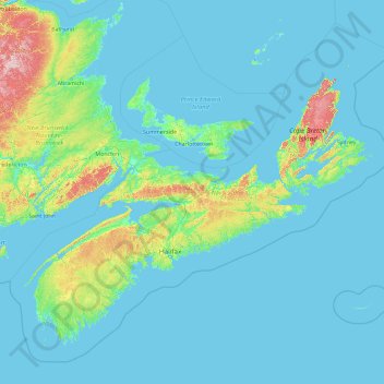
Name: Nova Scotia topographic map, elevation, terrain.
Location: Nova Scotia, Canada (43.18816 -66.68072 47.76107 -59.28871)
Average elevation: 41 m
Minimum elevation: -3 m
Maximum elevation: 746 m
Other topographic maps
Click on a map to view its topography, its elevation and its terrain.
Eleven Mile Lake
Canada > Nova Scotia > Municipality of the County of Annapolis > Nine Mile Woods
Average elevation: 161 m
Black Rattle
Canada > Nova Scotia > Municipality of the County of Annapolis > Cloud Lake
Average elevation: 190 m
Sesekinika
Canada > Ontario > Timiskaming District > Unorganized West Timiskaming
Average elevation: 320 m
Paul Lake
Canada > British Columbia > Thompson-Nicola Regional District > Area P (Rivers and the Peaks)
Average elevation: 926 m
Canmore
Canada > Alberta > Division No. 15
Elevation Place opened in April 2013 as Canmore's new recreation facility. Construction of the facility began in 2012 to go alongside the Canmore Recreation Centre (the community's old facility). The facility offers an 8-lane 25m lap pool, a world class climbing wall developed by Walltopia, two cardio rooms, a…
Average elevation: 1,565 m
London
London has a humid continental climate (Köppen Dfb), though due to its downwind location relative to Lake Huron and elevation changes across the city, it is virtually on the Dfa/Dfb (hot summer) boundary favouring the former climate zone to the southwest of the confluence of the South and North Thames Rivers,…
Average elevation: 269 m
Rosswood
Canada > British Columbia > Regional District of Kitimat-Stikine > Area C (Butedale/Kitlope/Kitsumkalum)
Average elevation: 311 m
Saskatoon
Canada > Saskatchewan > Saskatoon
Saskatoon lies on a long belt of rich, potassic chernozem in middle-southern Saskatchewan and is found in the aspen parkland biome. The lack of surrounding mountainous topography gives the city a relatively flat grid, though the city does sprawl over a few hills and into a few valleys. The lowest point in the…
Average elevation: 510 m
Burnaby
Canada > British Columbia > Metro Vancouver Regional District > Burnaby
Burnaby occupies 98.6 square kilometres (38.1 sq mi) and is located at the geographic centre of the Metro Vancouver area and home to the Metro Vancouver regional government in Metrotown. Situated between the city of Vancouver on the west and Port Moody, Coquitlam, and New Westminster on the east, Burnaby is…
Average elevation: 144 m