Geolocate

Papineau topographic map

Interactive map

Click on the map to display elevation.

About this map

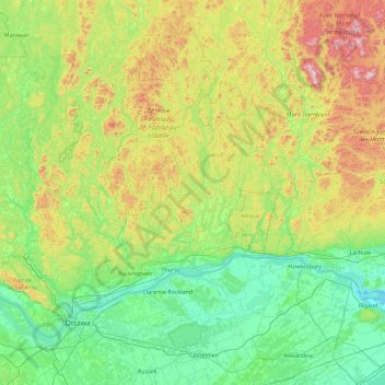
Name: Papineau topographic map, elevation, terrain.

Location: Papineau, Outaouais, Quebec, Canada (45.21255 -75.78148 46.49255 -74.50148)

Average elevation: 223 m

Minimum elevation: 20 m

Maximum elevation: 911 m

Other topographic maps

Click on a map to view its topography, its elevation and its terrain.

Sherbrooke

Canada > Quebec

Average elevation: 232 m

Mansfield-et-Pontefract

Canada > Quebec > Pontiac

Average elevation: 238 m

La Prairie

Canada > Quebec > Roussillon

Average elevation: 22 m

Quebec

Canada > Quebec > Urban agglomeration of Québec

Quebec City was built on the north bank of the Saint Lawrence River, where it narrows and meets the mouth of the Saint-Charles River. Old Quebec is located on top and at the foot of Cap-Diamant, which is on the eastern edge of a plateau called the promontory of Quebec (Quebec hill). Because of this topographic…

Average elevation: 117 m

Brome-Missisquoi

Canada > Quebec

Average elevation: 182 m

Angers

Canada > Quebec > Gatineau

Average elevation: 53 m

Chelsea

Canada > Quebec > Les Collines-de-l'Outaouais

Average elevation: 166 m

Gatineau

Canada > Quebec

Gatineau is located in southwestern Quebec, on the northern bank of the Gatineau River. It is situated at an elevation of around 50 m (164.042 ft) The Gatineau Hills are the foothills of the Laurentian Mountains and located in the region. It is also the location of the second largest urban park in the world.…

Average elevation: 127 m

Gatineau

Canada > Quebec > Gatineau

Average elevation: 107 m

Lac Caron

Canada > Quebec > Minganie > Aguanish

Average elevation: 91 m

Lac Caron

Canada > Quebec > Shawinigan > Shawinigan

Average elevation: 228 m

Shawinigan

Canada > Quebec > Shawinigan > Shawinigan

Average elevation: 137 m

Delson

Canada > Quebec > Roussillon

Average elevation: 27 m

Lac-Pikauba

Canada > Quebec > Lac-Pikauba

Average elevation: 736 m

Mirabel

Canada > Quebec > Mirabel

Average elevation: 59 m

Sainte-Marthe

Canada > Quebec > Sainte-Marthe

Average elevation: 77 m

Stratford

Canada > Quebec > Stratford

Average elevation: 323 m

Lévis

Canada > Quebec > Lévis

Average elevation: 90 m

Pink Lake

Canada > Quebec > Gatineau

Average elevation: 152 m

Les Moulins

Canada > Quebec

Average elevation: 39 m

Aguanish

Canada > Quebec > Aguanish

Average elevation: 65 m

Repentigny

Canada > Quebec > Repentigny

Average elevation: 14 m

Rosemont–La Petite-Patrie

Canada > Quebec > Montreal

Average elevation: 50 m

Lac Saint-Pierre

Canada > Quebec > Pierreville

Average elevation: 25 m

Anticosti Island

Canada > Quebec > Anticosti Island

Average elevation: 30 m

Charlesbourg

Canada > Quebec > Charlesbourg

Average elevation: 177 m

Saint Lawrence River

Canada > Quebec > Montreal

Average elevation: 14 m

Lake Memphremagog

Canada > Quebec > Potton

Average elevation: 311 m