
South East topographic map
Interactive map
Click on the map to display elevation.
About this map
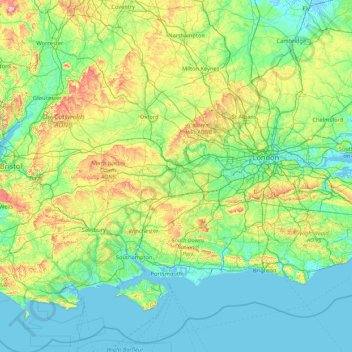
Name: South East topographic map, elevation, terrain.
Location: South East, England, United Kingdom (50.57468 -1.95728 52.19632 1.45177)
Average elevation: 69 m
Minimum elevation: -3 m
Maximum elevation: 491 m
Other topographic maps
Click on a map to view its topography, its elevation and its terrain.
Oakthorpe
United Kingdom > England > Leicestershire > North West Leicestershire
Average elevation: 94 m
Sutton
United Kingdom > England > London
Elevations in and around the town range from 115 metres (377 ft) AOD in Belmont to 23 metres (75 ft) in Sutton Common, at the start of the Pyl Brook stream.
Average elevation: 63 m
Malvern
United Kingdom > England > Worcestershire > Malvern Hills
Malvern lies in the Lower Severn/Avon plain affording it a degree of shelter caused by virtue of its nestling in between the Cotswold hills to the east, the Welsh Hills and Mountains to the west, and Birmingham plateau to the north. Although as with all the British Isles it has a maritime climate, the local…
Average elevation: 95 m
Berry Island
United Kingdom > England > Westmorland and Furness > Low Wood > High Brow Edge
Average elevation: 68 m
Tatenhill
United Kingdom > England > Staffordshire > East Staffordshire > Tatenhill
Average elevation: 80 m
Stow-on-the-Wold
United Kingdom > England > Gloucestershire > Cotswold District > Stow-on-the-Wold
Average elevation: 163 m
South Ascot
United Kingdom > England > Royal Borough of Windsor and Maidenhead > South Ascot
Average elevation: 74 m
Burton-on-Trent
United Kingdom > England > East Staffordshire > Burton-on-Trent
Burton is about 109 miles (175 km) north west of London, about 30 miles north east of Birmingham, the UK's second largest city and about 23 miles east of the county town Stafford. It is at the easternmost border of the county of Staffordshire with Derbyshire, its suburbs and the course of the River Trent…
Average elevation: 69 m
Redhill
United Kingdom > England > Surrey > Reigate and Banstead > Redhill
To the north, the town joins with the village of Merstham, north of which there is a "wind gap" in the chalk hills of the North Downs, at an elevation of 120 metres (390 ft) above sea level, through which the A23 road heads in from London. Geologists have speculated that there may once have been a…
Average elevation: 107 m
Swindon
United Kingdom > England > Swindon
Swindon has an oceanic climate (Cfb in the Köppen climate classification), like the vast majority of the British Isles, with cool winters and warm summers. The nearest official weather station is RAF Lyneham, about 10 miles (16 km) west southwest of Swindon town centre. The weather station's elevation is 145…
Average elevation: 108 m
Sinton Green
United Kingdom > England > Worcestershire > Malvern Hills > Grimley > Sinton Green
Average elevation: 42 m
Bedford
United Kingdom > England > Central Bedfordshire > Bedford
As with the rest of the United Kingdom, Bedford has a maritime climate, with a limited range of temperatures, and generally even rainfall throughout the year. The nearest Met Office weather station to Bedford is Bedford (Thurleigh) airport, about 6.5 miles (10.5 km) north of Bedford town centre at an elevation…
Average elevation: 37 m