Geolocate

Saskatchewan topographic map

Interactive map

Click on the map to display elevation.

About this map

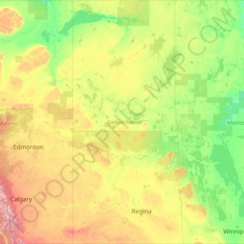
Name: Saskatchewan topographic map, elevation, terrain.

Location: Saskatchewan, Canada (48.99881 -110.00637 60.00003 -101.36191)

Average elevation: 511 m

Minimum elevation: 175 m

Maximum elevation: 3,227 m

Other topographic maps

Click on a map to view its topography, its elevation and its terrain.

McGowan Lake

Canada > Nova Scotia > Queens County > Westfield

Average elevation: 102 m

Smith Lake

Canada > Nova Scotia > Halifax County > Moser River

Average elevation: 63 m

Nias Island

Canada > Nunavut > Kivalliq Region

Average elevation: 31 m

Belyeas Cove

Canada > New Brunswick > Wickham Parish

Average elevation: 46 m

Mayo

Canada > Yukon

Average elevation: 499 m

Buck Lake

Canada > Alberta > County of Wetaskiwin

Average elevation: 901 m

Angers

Canada > Quebec > Gatineau

Average elevation: 53 m

Fraser

Canada > British Columbia > Stikine Region

Average elevation: 1,045 m

Canmore

Canada > Alberta > Division No. 15

Elevation Place opened in April 2013 as Canmore's new recreation facility. Construction of the facility began in 2012 to go alongside the Canmore Recreation Centre (the community's old facility). The facility offers an 8-lane 25m lap pool, a world class climbing wall developed by Walltopia, two cardio rooms, a…

Average elevation: 1,565 m

Sedalia

Canada > Alberta > Special Area No. 3

Average elevation: 778 m

Tonkin

Canada > Saskatchewan > Division No. 9 > Wallace No. 243

Average elevation: 517 m

Batoche

Canada > Saskatchewan > Division No. 15

Average elevation: 474 m

Fort Carlton

Canada > Saskatchewan > Division No. 15

Average elevation: 468 m

London

Canada > Ontario

London has a humid continental climate (Köppen Dfb), though due to its downwind location relative to Lake Huron and elevation changes across the city, it is virtually on the Dfa/Dfb (hot summer) boundary favouring the former climate zone to the southwest of the confluence of the South and North Thames Rivers,…

Average elevation: 269 m

Lac Caron

Canada > Quebec > Shawinigan > Shawinigan

Average elevation: 228 m

Shawinigan

Canada > Quebec > Shawinigan > Shawinigan

Average elevation: 137 m

Burnaby

Canada > British Columbia > Metro Vancouver Regional District > Burnaby

Burnaby occupies 98.6 square kilometres (38.1 sq mi) and is located at the geographic centre of the Metro Vancouver area and home to the Metro Vancouver regional government in Metrotown. Situated between the city of Vancouver on the west and Port Moody, Coquitlam, and New Westminster on the east, Burnaby is…

Average elevation: 144 m

Mount Queen Mary

Canada > British Columbia

Average elevation: 2,484 m

Long Point

Canada > Nova Scotia > Long Point

Average elevation: 85 m

Mount Cline

Canada > Alberta

Average elevation: 2,698 m

Georgian Bay

Canada > Ontario > Carling

Average elevation: 174 m

Victoria and Albert Mountains

Canada > Nunavut

Average elevation: 743 m

Magazine Island

Canada > Ontario > Penetanguishene

Average elevation: 200 m

Brandon

Canada > Manitoba > Brandon

Average elevation: 393 m

Peyto Glacier

Canada > Alberta

Average elevation: 2,421 m

Mount Robson

Canada > British Columbia

Average elevation: 3,042 m

Richardson Mountains

Canada > Yukon

Average elevation: 679 m

Mount Sir Douglas

Canada > Alberta

Average elevation: 2,737 m

Bray Island

Canada > Nunavut

Average elevation: 2 m

British Empire Range

Canada > Nunavut

Average elevation: 1,431 m

Crowfoot Glacier

Canada > Alberta

Average elevation: 2,550 m

Mount Farnham

Canada > British Columbia

Average elevation: 2,790 m

Agassiz

Canada > British Columbia > Agassiz

Average elevation: 48 m

Cambria Icefield

Canada > British Columbia > Kitsault

Average elevation: 1,556 m

Mount Hornickel

Canada > British Columbia

Average elevation: 2,417 m

Mount Saskatchewan

Canada > Alberta

Average elevation: 2,687 m

Sentinel Range

Canada > British Columbia

Average elevation: 1,839 m

Lacombe

Canada > Alberta > Lacombe

Average elevation: 895 m

Glace Bay

Canada > Nova Scotia > Glace Bay

Average elevation: 15 m

Pink Lake

Canada > Quebec > Gatineau

Average elevation: 152 m

Calgary

Canada > Alberta > Calgary

Average elevation: 1,106 m

Merritt

Canada > British Columbia > Merritt

Average elevation: 701 m

Lévis

Canada > Quebec > Lévis

Average elevation: 90 m

Grand Pre

Canada > Nova Scotia > Grand Pre

Average elevation: 21 m

Mirabel

Canada > Quebec > Mirabel

Average elevation: 59 m

Lower Lincoln

Canada > New Brunswick > Lower Lincoln

Average elevation: 8 m

Linwood

Canada > Nova Scotia > Linwood

Average elevation: 29 m

Ootischenia

Canada > British Columbia > Ootischenia

Average elevation: 605 m

Papineau

Canada > Quebec

Average elevation: 223 m

Squamish-Lillooet

Canada > British Columbia

Average elevation: 1,545 m

Central Coast

Canada > British Columbia

Average elevation: 789 m

Hillcrest

Canada > Nova Scotia > Hillcrest

Average elevation: 132 m

Clarendon Parish

Canada > New Brunswick

Average elevation: 160 m

Russell Island

Canada > Nunavut

Average elevation: 59 m

Ottawa

Canada > Ontario > Ottawa

Average elevation: 99 m

Northern Rockies

Canada > British Columbia

Average elevation: 512 m

Peace River

Canada > British Columbia

Average elevation: 1,118 m

Molega Lake

Canada > Nova Scotia > Molega Lake

Average elevation: 88 m

Saskatoon

Canada > Saskatchewan > Saskatoon

Saskatoon lies on a long belt of rich, potassic chernozem in middle-southern Saskatchewan and is found in the aspen parkland biome. The lack of surrounding mountainous topography gives the city a relatively flat grid, though the city does sprawl over a few hills and into a few valleys. The lowest point in the…

Average elevation: 510 m