
建平县 topographic map
Interactive map
Click on the map to display elevation.
About this map
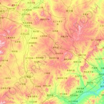
Name: 建平县 topographic map, elevation, terrain.
Location: 建平县, 朝阳市, 辽宁省, 中国 (41.30837 119.23158 42.39489 120.04565)
Average elevation: 615 m
Minimum elevation: 182 m
Maximum elevation: 1,262 m
Other topographic maps
Click on a map to view its topography, its elevation and its terrain.