
Borneo topographic map
Interactive map
Click on the map to display elevation.
About this map
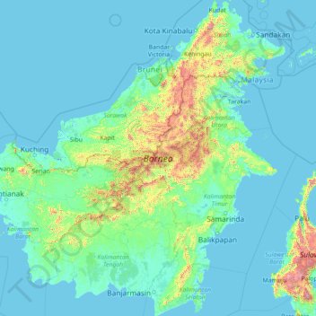
Name: Borneo topographic map, elevation, terrain.
Location: Borneo, Kalimantan, Indonesia (-4.17791 108.84066 7.03748 119.26689)
Average elevation: 141 m
Minimum elevation: -4 m
Maximum elevation: 3,808 m
Before sea levels rose at the end of the last Ice Age, Borneo was part of the mainland of Asia, forming, with Java and Sumatra, the upland regions of a peninsula that extended east from present day Indochina. The South China Sea and Gulf of Thailand now submerge the former low-lying areas of the peninsula. Deeper waters separating Borneo from neighbouring Sulawesi prevented a land connection to that island, creating the divide known as Wallace's Line between Asian and Australia-New Guinea biological regions. The island today is surrounded by the South China Sea to the north and northwest, the Sulu Sea to the northeast, the Celebes Sea and the Makassar Strait to the east, and the Java Sea and Karimata Strait to the south. To the west of Borneo are the Malay Peninsula and Sumatra. To the south and east are islands of Indonesia: Java and Sulawesi, respectively. To the northeast are the Philippine Islands. With an area of 743,330 square kilometres (287,000 sq mi), it is the third-largest island in the world, and is the largest island of Asia (the largest continent). Its highest point is Mount Kinabalu in Sabah, Malaysia, with an elevation of 4,095 m (13,435 ft).
Other topographic maps
Click on a map to view its topography, its elevation and its terrain.
Open
Indonesia > East Java > Kabupaten Malang
Open, Kabupaten Malang, East Java, Java, Indonesia
Average elevation: 922 m
Candidasa
Indonesia > Bali > Karangasem
Candidasa, Kecamatan Karangasem, Karangasem, Bali, 80851, Indonesia
Average elevation: 45 m
Berambang
Indonesia > Riau Islands > Karimun
Berambang, Karimun, Riau Islands, Sumatra, Indonesia
Average elevation: 3 m
Gampong Pande
Indonesia > Aceh > Banda Aceh > Gampong Pande
Gampong Pande, Kuta Raja, Banda Aceh, Aceh, Indonesia
Average elevation: 2 m
Gampong Jawa
Indonesia > Aceh > Banda Aceh > Gampong Jawa
Gampong Jawa, Kuta Raja, Banda Aceh, Aceh, Indonesia
Average elevation: 4 m
Keudah
Indonesia > Aceh > Banda Aceh > Keudah
Keudah, Banda Aceh, Aceh, 23121, Indonesia
Average elevation: 6 m
Peulanggahan
Indonesia > Aceh > Banda Aceh > Peulanggahan
Peulanggahan, Kuta Raja, Banda Aceh, Aceh, Indonesia
Average elevation: 5 m
Lampaseh Kota
Indonesia > Aceh > Banda Aceh > Lampaseh Kota
Lampaseh Kota, Banda Aceh, Aceh, 23241, Indonesia
Average elevation: 6 m
Merduati
Indonesia > Aceh > Banda Aceh > Merduati
Merduati, Kuta Raja, Banda Aceh, Aceh, Indonesia
Average elevation: 6 m
Calaca
Indonesia > North Sulawesi > Manado
Calaca, Manado, North Sulawesi, 95122, Indonesia
Average elevation: 11 m
Lesung Batu
Indonesia > South Sumatra > Muara Enim > Lesung Batu
Lesung Batu, Tanjung Agung, Muara Enim, South Sumatra, Indonesia
Average elevation: 151 m
RW 03
Indonesia > Jakarta Special Capital Region > Gondangdia
RW 03, Gondangdia, Menteng, Jakarta Special Capital Region, 10330, Indonesia
Average elevation: 10 m
Mataram
Indonesia > West Nusa Tenggara > Mataram
Mataram, Kec. Selaparang, West Nusa Tenggara, 83133, Indonesia
Average elevation: 144 m
Pluit
Indonesia > Jakarta Special Capital Region
Pluit, Penjaringan, North Jakarta, Jakarta Special Capital Region, Indonesia
Average elevation: 2 m
Kubutambahan
Kubutambahan, Buleleng, Bali, Lesser Sunda Islands, 81172, Indonesia
Average elevation: 33 m
North Jakarta
Indonesia > Jakarta Special Capital Region
North Jakarta, Jakarta Special Capital Region, Indonesia
Average elevation: 7 m
Bintan Island
Indonesia > Riau Islands > Tanjung Pinang
Bintan Island, Tanjung Pinang, Riau Islands, Indonesia
Average elevation: 6 m
Kelapa Gading
Indonesia > Jakarta Special Capital Region
Kelapa Gading, North Jakarta, Jakarta Special Capital Region, 14250, Indonesia
Average elevation: 5 m
Rancamaya
Indonesia > Central Java > Rancamaya
Rancamaya, Banyumas, Central Java, Indonesia
Average elevation: 257 m
Bukit Duri
Indonesia > Jakarta Special Capital Region
Bukit Duri, Tebet, South Jakarta, Jakarta Special Capital Region, 12840, Indonesia
Average elevation: 17 m
RW 11
Indonesia > Jakarta Special Capital Region > Sukabumi Utara
RW 11, Sukabumi Utara, Kebon Jeruk, West Jakarta, Jakarta Special Capital Region, 11540, Indonesia
Average elevation: 15 m
Sunter Agung
Indonesia > Jakarta Special Capital Region
Sunter Agung, Tanjung Priok, North Jakarta, Jakarta Special Capital Region, Indonesia
Average elevation: 4 m