Geolocate

Kalimantan topographic map

Interactive map

Click on the map to display elevation.

About this map

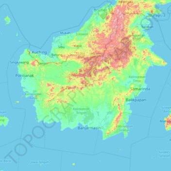
Name: Kalimantan topographic map, elevation, terrain.

Location: Kalimantan, Indonesia (-5.41389 108.13865 4.40782 119.66809)

Average elevation: 105 m

Minimum elevation: -4 m

Maximum elevation: 2,246 m

Other topographic maps

Click on a map to view its topography, its elevation and its terrain.

Ngadisari

Indonesia > East Java > Probolinggo

Average elevation: 2,057 m

Serangan

Indonesia > Bali > Denpasar

Average elevation: 1 m

Pulau Bali

Indonesia > Bali

Average elevation: 122 m

Tulungagung

Indonesia > East Java

Topographically, Tulungagung Regency is located 85 m (279 ft) above the sea level. The northwest part of the regency is a portion of the Wilis-Liman mountain range; the central part is lowland; the southern part is a portion of the rocky Kapur Kidul mountain range which is also an enormous source of marble. In…

Average elevation: 263 m

Sukabumi

Indonesia > West Java

At an altitude of approximately 584 m (1,916 ft), the city is a minor hill station resort, with a cooler climate than the surrounding lowlands. The area around Sukabumi is also a popular destination for whitewater rafting. Tea and Rubber production is a major industry in the area. The suburban area surrounding…

Average elevation: 570 m

Lovina

Indonesia > Bali > Buleleng > Kaliasem

Average elevation: 9 m

Banjar

Indonesia > Bali > Buleleng

Average elevation: 81 m

Pejarakan

Indonesia > Bali > Buleleng

Average elevation: 21 m

Ubud

Indonesia > Bali > Gianyar

Average elevation: 215 m

Kaliasem

Indonesia > Bali > Buleleng

Average elevation: 68 m

Kayuputih

Indonesia > Bali > Buleleng

Average elevation: 500 m

Melinggih

Indonesia > Bali > Gianyar

Average elevation: 408 m

Open

Indonesia > East Java > Kabupaten Malang

Average elevation: 922 m

Riau

Indonesia

In general, the geography of Riau consists of mountains, lowlands, and islands. The mountain area lies in the western part, namely the Bukit Barisan Mountains, near the border of West Sumatra. The elevation decreases towards the east, making most of the central and eastern part of the province covered with…

Average elevation: 115 m

Sanur

Indonesia > Bali

Average elevation: 5 m

Candidasa

Indonesia > Bali > Karangasem

Average elevation: 45 m

Natuna

Indonesia > Riau Islands

The airport resides at an elevation of 2 metres (6 ft 7 in) above mean sea level. It has one runway designated 18/36 with an asphalt surface measuring 2,560 m x 32 m (8,399 ft × 105 ft). The runway is planned to be widened to 80 m in 2020. Moreover, the airport has an apron measuring 120 m x 60 m and a…

Average elevation: 1 m

Berambang

Indonesia > Riau Islands > Karimun

Average elevation: 3 m

Bali

Indonesia

Bali's central mountains include several peaks over 2,000 metres (6,600 feet) in elevation and active volcanoes such as Mount Batur. The highest is Mount Agung (3,031 m, 9,944 ft), known as the "mother mountain", which is an active volcano rated as one of the world's most likely sites for a massive eruption…

Average elevation: 88 m

Tabanan

Indonesia > Bali

Jatiluwih village in Penebel District, north of Tabanan, has paddy fields following the contours of terraced land against the background of spellbinding Mount Batukaru and Mount Agung use traditional Balinese irrigation known as subak, Bali's community-based water control management system. Lies at an altitude…

Average elevation: 450 m

Gampong Pande

Indonesia > Aceh > Banda Aceh > Gampong Pande

Average elevation: 2 m

Gampong Jawa

Indonesia > Aceh > Banda Aceh > Gampong Jawa

Average elevation: 4 m

Keudah

Indonesia > Aceh > Banda Aceh > Keudah

Average elevation: 6 m

Peulanggahan

Indonesia > Aceh > Banda Aceh > Peulanggahan

Average elevation: 5 m

Lampaseh Kota

Indonesia > Aceh > Banda Aceh > Lampaseh Kota

Average elevation: 6 m

Merduati

Indonesia > Aceh > Banda Aceh > Merduati

Average elevation: 6 m

East Kalimantan

Indonesia > East Kalimantan

Average elevation: 218 m

Calaca

Indonesia > North Sulawesi > Manado

Average elevation: 11 m

Denpasar

Indonesia > Bali

Denpasar is located at an elevation of 4 m (13 ft) above sea level. While the total area of 127.78 km2 or 2.18% of the total area of Bali Province. From the use of land, 2,768 hectares of land are paddy, 10,001 hectares are dry land, while the remaining land area is 9 hectares.

Average elevation: 23 m

Serang

Indonesia > Banten > Serang

Average elevation: 79 m

Lesung Batu

Indonesia > South Sumatra > Muara Enim > Lesung Batu

Average elevation: 151 m

Southeast Sulawesi

Indonesia

Average elevation: 232 m

Mataram

Indonesia > West Nusa Tenggara > Mataram

Average elevation: 144 m

Kubutambahan

Indonesia > Bali > Buleleng

Average elevation: 33 m

Bengkulu

Indonesia > Bengkulu

Average elevation: 138 m

South Sulawesi

Indonesia

Average elevation: 223 m

West Nusa Tenggara

Indonesia

Average elevation: 31 m

Riau Islands

Indonesia

Average elevation: 18 m

South Sumatra

Indonesia

Average elevation: 114 m

Gorontalo

Indonesia

Topographically, the province is relatively low (0–40o), with the elevation ranging between 0–2,400 m (7,900 ft) above sea level. Its coastline length is more than 590 km (370 mi). Counting the Exclusive Economic Zone to the north where Philippines is at the border, the total sea area of the province is…

Average elevation: 124 m

East Kalimantan

Indonesia

Average elevation: 280 m

West Sulawesi

Indonesia

Average elevation: 215 m

Rancamaya

Indonesia > Central Java > Rancamaya

Average elevation: 257 m

Kampung Melayu

Indonesia > Bengkulu

Average elevation: 206 m