
汶川卧龙特别行政区 topographic map
Interactive map
Click on the map to display elevation.
About this map
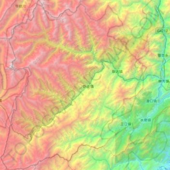
Name: 汶川卧龙特别行政区 topographic map, elevation, terrain.
Location: 汶川卧龙特别行政区, 汶川县, 阿坝藏族羌族自治州, 四川省, 中国 (30.76535 102.86052 31.32474 103.42207)
Average elevation: 3,042 m
Minimum elevation: 687 m
Maximum elevation: 6,201 m
Other topographic maps
Click on a map to view its topography, its elevation and its terrain.