
龙溪乡 topographic map
Interactive map
Click on the map to display elevation.
About this map
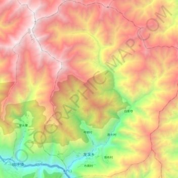
Name: 龙溪乡 topographic map, elevation, terrain.
Location: 龙溪乡, 汶川县, 阿坝藏族羌族自治州, 四川省, 中国 (31.54328 103.47093 31.71789 103.64648)
Average elevation: 3,203 m
Minimum elevation: 1,429 m
Maximum elevation: 4,801 m
龙溪乡境内热量充足,阳光充沛,雨量集中。年温差小,日温差大。全乡境内幅员214.3平方公里,海拔1500~2800米之问。
Other topographic maps
Click on a map to view its topography, its elevation and its terrain.