
雀儿山 topographic map
Interactive map
Click on the map to display elevation.
About this map
Name: 雀儿山 topographic map, elevation, terrain.
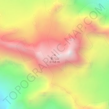
Location: 雀儿山, 德格县, 甘孜藏族自治州, 四川省, 中国 (31.78555 99.06794 31.78565 99.06804)
Average elevation: 5,517 m
Minimum elevation: 4,728 m
Maximum elevation: 6,164 m
雀儿山(藏语称措拉,意为大鸟羽翼)是位于中国四川省甘孜藏族自治州境内的一条山脉,属于横断山脉北部沙鲁里山的余脉。雀儿山位于青藏高原的东南缘,呈西北东南走向,北衔莫拉山,南接沙鲁里山。同名主峰(藏语称绒峨扎峰)位于山脉南段,海拔6168米。由于主峰突兀于周围十座5500米的群峰之上,显得主峰特别高峻挺拔,故有“爬上雀儿山,鞭子打着天”之说。川藏公路北线(317国道)就从主峰北坡穿过,该路段有川藏线“第一高”、“第一险”之称。雀儿山隧道于2012年9月动工,2017年9月26日建成通车。
Other topographic maps
Click on a map to view its topography, its elevation and its terrain.