
平通镇 topographic map
Interactive map
Click on the map to display elevation.
About this map
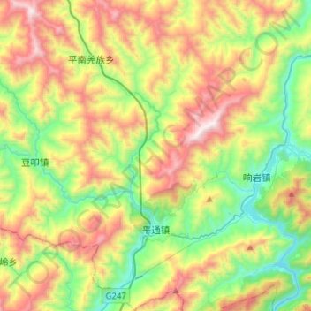
Name: 平通镇 topographic map, elevation, terrain.
Location: 平通镇, 平武县, 绵阳市, 四川省, 中国 (32.00466 104.62986 32.21849 104.73491)
Average elevation: 1,217 m
Minimum elevation: 608 m
Maximum elevation: 2,173 m
Other topographic maps
Click on a map to view its topography, its elevation and its terrain.