
Bình Phước Province topographic map
Interactive map
Click on the map to display elevation.
About this map
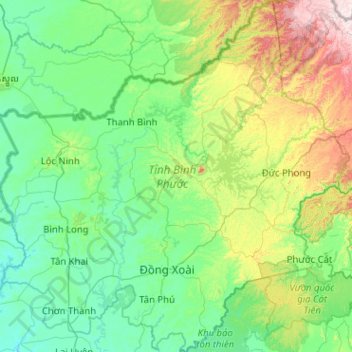
Name: Bình Phước Province topographic map, elevation, terrain.
Location: Bình Phước Province, Vietnam (11.30159 106.41167 12.29827 107.42714)
Average elevation: 190 m
Minimum elevation: 15 m
Maximum elevation: 967 m
Bình Phước province is relatively flat with an elevation of between 50 metres (160 ft) and 200 metres (660 ft) throughout most of the province. The elevation is gradually higher towards the east of the province and reach around 500 metres (1,600 ft) near parts of the border with Đắk Nông province of the Central Highlands. The highest elevation is Bà Rá mountain (736 metres (2,415 ft)) in the centre of the province. There are several hills around the province with heights of up to around 200 metres (660 ft) in the west and 300 metres (980 ft) in the southeast.
Other topographic maps
Click on a map to view its topography, its elevation and its terrain.
Buôn Ma Thuột
Buôn Ma Thuột, Đắk Lắk Province, Vietnam
Average elevation: 442 m
Dầu Tiếng District
Dầu Tiếng District, Bình Dương Province, Vietnam
Average elevation: 31 m
Phú Giáo District
Phú Giáo District, Bình Dương Province, Vietnam
Average elevation: 55 m
Định Quán
Vietnam > Dong Nai province > Định Quán District
Định Quán, Định Quán District, Đồng Nai Province, Vietnam
Average elevation: 141 m
Việt Yên District
Việt Yên District, Bắc Giang Province, 21000, Vietnam
Average elevation: 9 m
Hạ Long City
Hạ Long City, Quảng Ninh Province, Vietnam
Average elevation: 97 m
Hue City
Vietnam > Thừa Thiên Huế Province
Hue City, Thừa Thiên Huế Province, 54000, Vietnam
Average elevation: 24 m
Binh Tan District
Binh Tan District, Ho Chi Minh City, 71914, Vietnam
Average elevation: 5 m
Củ Chi District
Củ Chi District, Ho Chi Minh City, Vietnam
Average elevation: 11 m
Hanoi
Vietnam > Hanoi > Hoan Kiem District
Hanoi, Hoan Kiem District, Hanoi, 11415, Vietnam
Average elevation: 9 m
Kiến Giang
Vietnam > Quang Binh province > Kiến Giang
Kiến Giang, Lệ Thủy District, Quang Binh province, Vietnam
Average elevation: 3 m
Ho Chi Minh City
Vietnam > Ho Chi Minh City > Ho Chi Minh City
Ho Chi Minh City, District 1, Ho Chi Minh City, 00084, Vietnam
Average elevation: 6 m
Mai Châu District
Mai Châu District, Hoa Binh province, Vietnam
Average elevation: 559 m
Ngoc Hien District
Ngoc Hien District, Ca Mau province, Vietnam
Average elevation: 1 m