
Make a donation
Kien Giang topographic map
Click on the map to display elevation.
Make a donation
About this map
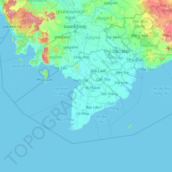
Name: Kien Giang topographic map, elevation, terrain.
Location: Kien Giang, Vietnam (7.31139 102.65339 12.51139 107.85339)
Average elevation: 58 m
Minimum elevation: -3 m
Maximum elevation: 1,678 m
Make a donation
Other topographic maps
Click on a map to view its topography, its elevation and its terrain.
Hue City
Vietnam > Thừa Thiên Huế Province
Located near Trường Sơn mountain range, Huế city is a plain area in the lower reaches of the Perfume and Bo rivers, with an average altitude of 3–4 m above sea level and often flooded when the river's headwaters Hương has medium and large rainfall. This plain area is relatively flat, although there…
Average elevation: 24 m
Make a donation
Bình Phước Province
Bình Phước province is relatively flat with an elevation of between 50 metres (160 ft) and 200 metres (660 ft) throughout most of the province. The elevation is gradually higher towards the east of the province and reach around 500 metres (1,600 ft) near parts of the border with Đắk Nông province of…
Average elevation: 190 m
Make a donation
Đà Nẵng
Geologically, Da Nang is at the edge of a Paleozoic fold belt known as the Truong Son Orogenic Zone, whose main deformation occurred during the early Carboniferous period. Da Nang's topography is dominated by the steep Annamite mountain range to the north and north-west, which features peaks ranging from 700…
Average elevation: 99 m
Make a donation