
Make a donation
Africa topographic map
Click on the map to display elevation.
Make a donation
Africa
Africa's topography is a complex tapestry of plateaus, mountains, valleys, and deserts. The continent is dominated by vast plateaus, with elevations averaging around 1,000 meters (3,281 feet), especially prominent in the south and east. The Ethiopian Highlands, often referred to as the "Roof of Africa," rise to formidable heights, with peaks such as Ras Dejen reaching 4,550 meters (14,928 feet). The Great Rift Valley, a significant geological feature, stretches from the Red Sea down to Mozambique, creating deep depressions hosting some of Africa's largest lakes, including Lake Tanganyika and Lake Malawi, and marked by volcanic mountains such as Mount Kilimanjaro, Africa's highest point at 5,895 metres (19,341 ft) and Mount Kenya. In the northwest, the Atlas Mountains extend through Morocco, Algeria, and Tunisia, with Mount Toubkal standing as the range's highest point at 4,167 meters (13,671 feet). Contrasting these elevations, the Sahara Desert sprawls across North Africa, characterized by expansive sand dunes and rocky plateaus. The southern part of Africa includes the Kalahari Desert and the Drakensberg Mountains, which rise steeply from the plains. This diverse terrain influences the continent's climate, biodiversity, and human settlements.
Make a donation
About this map
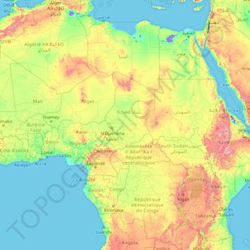
Name: Africa topographic map, elevation, terrain.
Location: Africa (-13.49757 -7.24219 36.50243 42.75781)
Average elevation: 462 m
Minimum elevation: -415 m
Maximum elevation: 4,436 m
Make a donation
Other topographic maps
Click on a map to view its topography, its elevation and its terrain.
Pulau Bali
Bali's central mountains include several peaks over 2,000 metres (6,600 feet) in elevation and active volcanoes such as Mount Batur. The highest is Mount Agung (3,031 m; 9,944 ft), known as the "mother mountain", which is an active volcano rated as one of the world's most likely sites for a massive eruption…
Average elevation: 122 m
Turkey
Turkey's topography is a diverse tapestry of mountains, plateaus, and coastal plains that create a strikingly varied landscape. The country is predominantly characterized by the Anatolian Plateau, a semi-arid highland that stretches across central Turkey, with elevations ranging from 700 to 2,000 meters. This…
Average elevation: 487 m
Japan
Japan's topography is dominated by rugged, mountainous terrain, with over four-fifths of its landmass consisting of mountains. The country's volcanic origins contribute to the striking landscape, with towering peaks and active volcanoes, including the iconic Mount Fuji, which rises to 12,388 feet (3,776…
Average elevation: 58 m
Make a donation
Norway
At 385,207 square kilometres (148,729 sq mi) (including Svalbard and Jan Mayen; 323,808 square kilometres (125,023 sq mi) without), much of the country is dominated by mountainous or high terrain, with a great variety of natural features caused by prehistoric glaciers and varied topography. The most noticeable…
Average elevation: 143 m
Marine Corps Base Camp Pendleton
USA > California > Marine Corps Base Camp Pendleton
Average elevation: 173 m
Gran Canaria
Gran Canaria is located in the Atlantic Ocean in a region known as Macaronesia about 150 kilometres (93 mi) off the northwestern coast of Africa and about 1,350 km (840 mi) from Europe. With an area of 1,560 km2 (600 sq mi) and an altitude of 1,956 m (6,417 ft) at Morro de la Agujereada, Gran Canaria is the…
Average elevation: 335 m
Make a donation
Make a donation
Guangdong Province
Guangdong faces the South China Sea to the south and has a total of 4,300 km (2,700 mi) of coastline. The Leizhou Peninsula is on the southwestern end of the province. There are a few inactive volcanoes on Leizhou Peninsula. The Pearl River Delta is the convergent point of three upstream rivers: the East…
Average elevation: 194 m
Make a donation
Denpasar
Denpasar is located at an elevation of 4 m (13 ft) above sea level. While the total area of 125.98 km2 or 2.18% of the total area of Bali Province. From the use of land, 2,768 hectares of land are paddy, 10,001 hectares are dry land, while the remaining land area is 9 hectares.
Average elevation: 7 m
Make a donation
Make a donation
Tokyo
The mainland portion of Tokyo lies northwest of Tokyo Bay and measures about 90 km (56 mi) east to west and 25 km (16 mi) north to south. The average elevation in Tokyo is 40 m (131 ft). Chiba Prefecture borders it to the east, Yamanashi to the west, Kanagawa to the south, and Saitama to the north. Mainland…
Average elevation: 39 m
Thailand
Thailand comprises several distinct geographic regions, partly corresponding to the provincial groups. The north of the country is the mountainous area of the Thai highlands, with the highest point being Doi Inthanon in the Thanon Thong Chai Range at 2,565 metres (8,415 ft) elevation. The northeast, Isan,…
Average elevation: 156 m
Make a donation
Huánuco
Huánuco has a rugged topography, comprising parts of the Sierra and the High Jungle (mountain rim) regions. Being equidistant from the north and the south of the country, it has the privilege of having a mild weather with an average annual temperature of 20 °C (68 °F).
Average elevation: 1,829 m
Make a donation
Sri Lanka
The climate is tropical and warm because of moderating effects of ocean winds. Mean temperatures range from 17 °C (62.6 °F) in the Central Highlands, where frost may occur for several days in the winter, to a maximum of 33 °C (91.4 °F) in low-altitude areas. Average yearly temperatures range from 28 °C…
Average elevation: 50 m
Make a donation
City of Medan
Medan's elevation varies between 2.5 and 37.5 m (8 ft 2 in and 123 ft 0 in) above sea level, with the Barisan Mountains to the south, and volcanoes such as Sibayak Mountain and Sinabung Mountain 50 to 70 km (31 to 43 mi) from the city.
Average elevation: 19 m
Bury St Edmunds
United Kingdom > England > Suffolk > West Suffolk
The name Bury is etymologically connected with borough, which has cognates in other Germanic languages such as German Burg 'fortress, castle' and Old Norse borg 'wall, castle'; and Gothic baurg 'city'. They all derive from Proto-Germanic *burgs 'fortress'. This in turn derives from the Proto-Indo-European root…
Average elevation: 54 m
Make a donation
Make a donation
Make a donation
Colorado
Thirty days later on February 28, 1861, outgoing U.S. President James Buchanan signed an Act of Congress organizing the free Territory of Colorado. The original boundaries of Colorado remain unchanged except for government survey amendments. In 1776, Spanish priest Silvestre Vélez de Escalante recorded that…
Average elevation: 2,060 m
Rwanda
Rwanda, officially the Republic of Rwanda, is a landlocked country in the Great Rift Valley of East Africa, where the African Great Lakes region and Southeast Africa converge. Located a few degrees south of the Equator, Rwanda is bordered by Uganda, Tanzania, Burundi, and the Democratic Republic of the Congo.…
Average elevation: 1,625 m
Make a donation
Germany
Germany is the seventh-largest country in Europe. It borders Denmark to the north, Poland and the Czech Republic to the east, Austria and Switzerland to the south, and France, Luxembourg, Belgium, and the Netherlands to the west. Germany is also bordered by the North Sea and, at the north-northeast, by the…
Average elevation: 237 m
Costa Rica
Costa Rica is highly vulnerable to extreme weather events, which can be exacerbated by climate change. The majority of Costa Rica’s population (78%) and economic activity (80% of GDP) are concentrated in regions highly vulnerable to various natural hazards, such as floods, landslides, cyclones, storm surges,…
Average elevation: 101 m
Kuala Lumpur
Located in the centre of Selangor state, Kuala Lumpur was a territory of Selangor State Government. In 1974, Kuala Lumpur was split off from Selangor to form the first Federal Territory governed directly by the Malaysian federal government. Its location in the most developed state on the west coast of…
Average elevation: 80 m
Morocco
In the Rif, Middle and High Atlas Mountains, there exist several different types of climates: Mediterranean along the coastal lowlands, giving way to a humid temperate climate at higher elevations with sufficient moisture to allow for the growth of different species of oaks, moss carpets, junipers, and…
Average elevation: 371 m
Make a donation
Tapiola
Architects Aarne Ervi, Viljo Revell, Aulis Blomstedt and Markus Tavio were charged with designing the eastern neighbourhood based on Meurman's plan.[11] They were required to design buildings suited to the surrounding environment and the topography of the area.[12]
Average elevation: 10 m
Vaal Dam
South Africa > Free State > Fezile Dabi District Municipality > Metsimaholo Local Municipality > Deneysville
Average elevation: 1,481 m
Make a donation
Florida
Florida's topography is characterized by its predominantly flat landscape, with the highest elevation being Britton Hill at just 345 feet (105 meters) above sea level, making it the lowest high point of any U.S. state. The state is primarily divided into three physiographic regions: the Atlantic Coastal Plain,…
Average elevation: 6 m
Wonderkop Nature Reserve
South Africa > Limpopo > Capricorn District Municipality
Average elevation: 904 m
Western Australia
Because the only mountain-building since then has been of the Stirling Range with the rifting from Antarctica, the land is extremely eroded and ancient, with no part of the state above 1,249 metres (4,098 ft) AHD (at Mount Meharry in the Hamersley Range of the Pilbara region). Most of the state is a low…
Average elevation: 194 m
Make a donation
New York County
United States > New York > New York
Parkland covers a total of 2,659 acres (10.76 km2), accounting for 18.2% of the borough's land area; the 840-acre (3.4 km2) Central Park is the borough's largest park, comprising 31.6% of Manhattan's parkland. Designed by Frederick Law Olmsted and Calvert Vaux, the park is anchored by the 12-acre (4.9 ha)…
Average elevation: 16 m
Make a donation
New Guinea
A spine of east–west mountains, the New Guinea Highlands, dominates the geography of New Guinea, stretching over 1,600 km (1,000 mi) across the island, with many mountains over 4,000 m (13,100 ft). The western half of the island contains the highest mountains in Oceania, with its highest point, Puncak Jaya,…
Average elevation: 101 m
Haiti
Haiti is the most mountainous country in the Caribbean, its terrain consists of mountains interspersed with small coastal plains and river valleys. The climate is tropical, with some variation depending on altitude. The highest point is Pic la Selle, at 2,680 meters (8,793 ft).
Average elevation: 177 m
Make a donation
Iraq
The capital, Ninus or Nineveh, was taken by the Medes under Cyaxares, and some 200 years after Xenophon passed over its site, then mere mounds of earth. It remained buried until 1845, when Botta and Layard discovered the ruins of the Assyrian cities. The principal remains are those of Khorsabad, 16 km (10 mi)…
Average elevation: 633 m
Make a donation
Chaozhou
The Chaozhou territory is mountainous. In particular, the nearby Phoenix Mountain's peak is located 1,497 meters (4,911 ft) above sea level. The main nearby rivers are the Huanggang River and the Han River. The Han River flows from west to southeast, and ramps through downtown Chaozhou; the Huanggang river…
Average elevation: 209 m
Serra de Tramuntana
Spain > Balearic Islands > Serra de Tramuntana
The climate in the Tramuntana Range is significantly wetter than the rest of the island, recording as much as 1507 mm (59.3 inches) of precipitation per year, in comparison with some other parts of the island where annual rainfall is less than 400mm (15 inch). It is also cooler due to the altitude, and a few…
Average elevation: 175 m
Make a donation
Hakai Passage
Canada > British Columbia > Central Coast Regional District > Area A (Ocean Falls/Outer Coast)
Average elevation: 30 m
Adıyaman
Adıyaman has a hot summer Mediterranean climate (Csa) under both the Köppen and Trewartha classifications, with some continental characteristics. Summers are very hot and very dry. Temperatures often reach 40 °C (104 °F) at the height of summer. The highest recorded temperature was 45.3 °C (113.5 °F) on…
Average elevation: 814 m
Greece
Greece's topography is predominantly mountainous, with approximately 80% of its terrain consisting of mountains or hills, making it one of the most mountainous countries in Europe. The Pindus mountain range, often referred to as the "spine of Greece," runs through the center of the mainland from northwest to…
Average elevation: 170 m
China
China's climate is mainly dominated by dry seasons and wet monsoons, which lead to pronounced temperature differences between winter and summer. In the winter, northern winds coming from high-latitude areas are cold and dry; in summer, southern winds from coastal areas at lower latitudes are warm and moist.…
Average elevation: 901 m
Make a donation
Death Valley
Death Valley's Badwater Basin is the point of lowest elevation in North America, at 282 feet (86 m) below sea level. It is 84.6 miles (136.2 km) east-southeast of Mount Whitney – the highest point in the contiguous United States, with an elevation of 14,505 feet (4,421 m). On the afternoon hours of July 10,…
Average elevation: 1,085 m
Municipality of Minoa Pediados
Greece > Region of Crete > Heraklion Regional Unit
Average elevation: 438 m
Make a donation
Mexico
The majority of Mexican central and northern territories are located at high altitudes, and as such the highest elevations are found at the Trans-Mexican Volcanic Belt which crosses Mexico east to west: Pico de Orizaba (5,700 m or 18,701 ft), Popocatépetl (5,462 m or 17,920 ft) and Iztaccihuatl (5,286 m or…
Average elevation: 412 m
Great Britain
Great Britain's topography is characterized by a diverse landscape shaped by its geological history. The island predominantly features lowland terrain in the east and south, with rolling countryside and plains, while the western and northern regions are marked by hills and mountains. Notable upland areas…
Average elevation: 52 m
Make a donation
Vietnam
Due to differences in latitude and the marked variety in topographical relief, Vietnam's climate tends to vary considerably for each region. During the winter or dry season, extending roughly from November to April, the monsoon winds usually blow from the northeast along the Chinese coast and across the Gulf…
Average elevation: 173 m
Tabanan
Jatiluwih village in Penebel District, north of Tabanan, has paddy fields following the contours of terraced land against the background of spellbinding Mount Batukaru and Mount Agung use traditional Balinese irrigation known as subak, Bali's community-based water control management system. Lies at an altitude…
Average elevation: 450 m
Make a donation
Nakhon Nayok Province
The northern part of the province is in the Sankamphaeng Range, the southern prolongation of the Dong Phaya Yen Mountains, with the highest elevation the 1,292-meter-high Yod Khao Kiew. Most of that area is covered by the Khao Yai National Park, 2,166 km2 (836 sq mi), along with three other national parks,…
Average elevation: 183 m
Make a donation