
Thank you for supporting this site ❤️
Make a donation
Make a donation
Lantau Island topographic map
Click on the map to display elevation.
Thank you for supporting this site ❤️
Make a donation
Make a donation
About this map
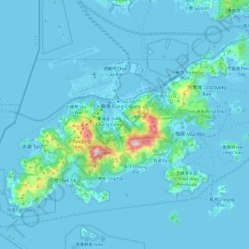
Name: Lantau Island topographic map, elevation, terrain.
Average elevation: 55 m
Minimum elevation: -15 m
Maximum elevation: 878 m
Thank you for supporting this site ❤️
Make a donation
Make a donation
Other topographic maps
Click on a map to view its topography, its elevation and its terrain.
Lantau Peak
China > Hong Kong > Islands District
Lantau Peak is located in central Lantau Island, with an elevation of 934 meters above sea level (23 metres shorter than Tai Mo Shan, Hong Kong's highest peak). Under the Köppen climate classification, Lantau Peak features a subtropical highland climate. Due to its elevation, strong winds and fog occur…
Average elevation: 422 m
Thank you for supporting this site ❤️
Make a donation
Make a donation