Geolocate

Chaozhou topographic map

Interactive map

Click on the map to display elevation.

About this map

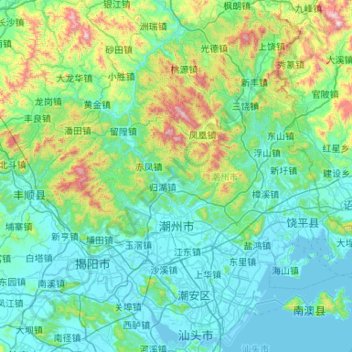
Name: Chaozhou topographic map, elevation, terrain.

Location: Chaozhou, Guangdong Province, China (23.34644 116.36375 24.23576 117.41973)

Average elevation: 209 m

Minimum elevation: -2 m

Maximum elevation: 1,490 m

The Chaozhou territory is mountainous. In particular, the nearby Phoenix Mountain's peak is located 1,497 meters (4,911 ft) above sea level. The main nearby rivers are the Huanggang River and the Han River. The Han River flows from west to southeast, and ramps through downtown Chaozhou; the Huanggang river flows roughly from north to south through the territory of Raoping, emptying into the sea. These two rivers provide abundant water for Chaozhou. Hills account for 65% of the total land area within the city, mainly in Raoping and Northern Chaoan. To the north of the city, there is a wide mountainous area suitable for tea cultivation; the lower-altitude areas nearby are mainly suitable for growing bamboo, peach, plum, olive, and pineapple. On the banks of the Han River, there is fertile land used for rice, sweet potato, peanut, soybean, carrot, orange, peach, and banana cultivation.

Wikipedia (CC-BY-SA 3.0)

Other topographic maps

Click on a map to view its topography, its elevation and its terrain.

Shenzhen

China > Guangdong Province

Shenzhen, Guangdong Province, China

Average elevation: 48 m

大万

China > Guangdong Province > Pingshan District

大万, Maluan Sub-district, Pingshan District, Shenzhen, Guangdong Province, 518118, China

Average elevation: 49 m

Shunde District

China > Guangdong Province

Shunde District, Foshan, Guangdong Province, China

Average elevation: 5 m

Huadu District

China > Guangdong Province > Guangzhou City

Huadu District, Guangzhou City, Guangdong Province, 510800, China

Average elevation: 56 m

Danxia

China > Guangdong Province > Renhua County

Danxia, Renhua County, Shaoguan, Guangdong Province, China

Average elevation: 231 m

Henan

China > Guangdong Province > Taishan > Jiangmen

Henan, Taishan, Jiangmen, Guangdong Province, China

Average elevation: 9 m

Muxi Reservoir

China > Guangdong Province > Xilian > Muxicun

Muxi Reservoir, Muxicun, Xilian, Wujiang District, Shaoguan, Guangdong Province, China

Average elevation: 103 m

Dongguan

China > Guangdong Province

Dongguan, Guangdong Province, China

Average elevation: 24 m

Guangzhou City

China > Guangdong Province

Guangzhou City, Guangdong Province, China

Average elevation: 98 m

Tugang

China > Guangdong Province > Taishan > Jiangmen

Tugang, Taishan, Jiangmen, Guangdong Province, China

Average elevation: 68 m

Jiangmen

China > Guangdong Province > Jiangmen

Jiangmen, Guangdong Province, China

Average elevation: 31 m

Maoming City

China > Guangdong Province

Maoming City, Guangdong Province, China

Average elevation: 171 m

Foshan

China > Guangdong Province > Foshan

Foshan, Guangdong Province, China

Average elevation: 39 m

Jieyang City

China > Guangdong Province > Jieyang City

Jieyang City, Guangdong Province, China

Average elevation: 98 m

Zhanjiang City

China > Guangdong Province

Zhanjiang City, Guangdong Province, China

Average elevation: 23 m

Huizhou

China > Guangdong Province

Huizhou, Guangdong Province, China

Average elevation: 134 m

Zhaoqing City

China > Guangdong Province > Zhaoqing City

Zhaoqing City, Guangdong Province, China

Average elevation: 200 m

Meizhou

China > Guangdong Province

Meizhou, Guangdong Province, China

Average elevation: 297 m

Shantou

China > Guangdong Province > Shantou

Shantou, Guangdong Province, China

Average elevation: 58 m