
理塘县 topographic map
Interactive map
Click on the map to display elevation.
About this map
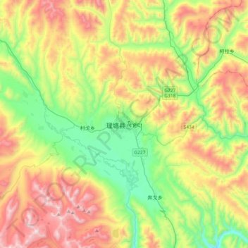
Name: 理塘县 topographic map, elevation, terrain.
Location: 理塘县, 甘孜藏族自治州, 四川省, 中国 (29.83301 100.11176 30.15301 100.43176)
Average elevation: 4,305 m
Minimum elevation: 3,768 m
Maximum elevation: 5,109 m
理塘县(藏文:ལི་ཐང་རྫོང,威利转写:li thang rdzong,藏语拼音:Litang Zong)是中华人民共和国四川省甘孜藏族自治州辖县,位于甘孜州西南部,东毗雅江县,南邻木里县、稻城县、乡城县,西接巴塘县,北连白玉县、新龙县。舊名理化縣,屬西康省。全县总面积14,352平方公里,平均海拔4,014米,2020年全县总人口67,293人。
Other topographic maps
Click on a map to view its topography, its elevation and its terrain.