
Make a donation
Mehrstetten topographic map
Click on the map to display elevation.
Make a donation
About this map
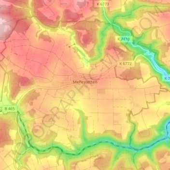
Name: Mehrstetten topographic map, elevation, terrain.
Average elevation: 738 m
Minimum elevation: 612 m
Maximum elevation: 823 m
Make a donation
Other topographic maps
Click on a map to view its topography, its elevation and its terrain.
Traifelberg
Deutschland > Baden-Württemberg > Landkreis Reutlingen > Lichtenstein
Average elevation: 709 m
Steighof
Deutschland > Baden-Württemberg > Landkreis Reutlingen > Münsingen > Bichishausen
Average elevation: 702 m
Make a donation
Kochstetten
Deutschland > Baden-Württemberg > Landkreis Reutlingen > Hayingen
Average elevation: 711 m
Wasserstetten
Deutschland > Baden-Württemberg > Landkreis Reutlingen > Dapfen
Average elevation: 723 m
Make a donation
Hohe Warte
Deutschland > Baden-Württemberg > Landkreis Reutlingen > St. Johann
Average elevation: 744 m
Schloss Pfullingen
Deutschland > Baden-Württemberg > Landkreis Reutlingen > Pfullingen
Average elevation: 457 m
Make a donation
Schlossberg
Deutschland > Baden-Württemberg > Landkreis Reutlingen > Bad Urach
Average elevation: 562 m
Donnstetten
Deutschland > Baden-Württemberg > Landkreis Reutlingen > Römerstein
Average elevation: 810 m
Neuhausen an der Erms
Deutschland > Baden-Württemberg > Landkreis Reutlingen > Metzingen > Neuhausen an der Erms
Average elevation: 427 m
Sirchingen
Deutschland > Baden-Württemberg > Landkreis Reutlingen > Bad Urach
Average elevation: 701 m
Make a donation
Bleichstetten
Deutschland > Baden-Württemberg > Landkreis Reutlingen > St. Johann
Average elevation: 742 m
Undingen
Deutschland > Baden-Württemberg > Landkreis Reutlingen > Sonnenbühl
Das Naturschutzgebiet Ruchberg liegt westlich von Willmandingen. Südwestlich von Erpfingen beginnt das Landschaftsschutzgebiet Laucherttal mit Nebentälern. Mit den Gebieten Salmendingen/Sonnenbühl, Albtrauf zwischen Mössingen und Gönningen und Albtrauf Pfullingen hat die Gemeinde Anteil an drei…
Average elevation: 787 m
Make a donation
Steinhilben
Deutschland > Baden-Württemberg > Landkreis Reutlingen > Trochtelfingen
Average elevation: 779 m
Make a donation
Engstingen
Deutschland > Baden-Württemberg > Landkreis Reutlingen
Engstingen liegt am Nordrand der Schwäbischen Alb im Bereich der Mittleren Kuppenalb, in 680 bis 750 Meter Höhe auf der Albhochfläche oberhalb des Albtraufs. Es liegt im Tal der Ur-Lauter, etwa 15 km Luftlinie südlich der Kreisstadt Reutlingen.
Average elevation: 738 m
Waldsiedlung Beerenhalde
Deutschland > Baden-Württemberg > Landkreis Reutlingen > Sonnenbühl
Average elevation: 773 m
Make a donation
Willmandingen
Deutschland > Baden-Württemberg > Landkreis Reutlingen > Sonnenbühl
Das Naturschutzgebiet Ruchberg liegt westlich von Willmandingen. Südwestlich von Erpfingen beginnt das Landschaftsschutzgebiet Laucherttal mit Nebentälern. Mit den Gebieten Salmendingen/Sonnenbühl, Albtrauf zwischen Mössingen und Gönningen und Albtrauf Pfullingen hat die Gemeinde Anteil an drei…
Average elevation: 786 m
Erpfingen
Deutschland > Baden-Württemberg > Landkreis Reutlingen > Sonnenbühl
Average elevation: 773 m
Walddorf
Deutschland > Baden-Württemberg > Landkreis Reutlingen
Walddorfhäslach liegt am Rande des Naturparks Schönbuch. Das Gemeindegebiet erstreckt sich über eine Höhenlage von 336 m ü. NN im Schaichtal bis 501 m ü. NN auf der Walddorfer Platte.
Average elevation: 414 m
Make a donation
Offenhausen
Deutschland > Baden-Württemberg > Landkreis Reutlingen > Gomadingen
Average elevation: 724 m
Gächingen
Deutschland > Baden-Württemberg > Landkreis Reutlingen > St. Johann
Average elevation: 732 m
Make a donation
Degerschlacht
Deutschland > Baden-Württemberg > Landkreis Reutlingen > Reutlingen
Average elevation: 376 m
Make a donation
Bärenhöhle
Deutschland > Baden-Württemberg > Landkreis Reutlingen > Erpfingen
Average elevation: 772 m
Ableitung Erms
Deutschland > Baden-Württemberg > Landkreis Reutlingen > Dettingen an der Erms
Average elevation: 482 m
Oberwilzingen
Deutschland > Baden-Württemberg > Landkreis Reutlingen > Hayingen
Das Dorf liegt südöstlich von Hayingen auf einer Hochfläche der Schwäbischen Alb über dem Tal der Großen Lauter auf 595 Meter Meereshöhe.
Average elevation: 637 m
Gönningen
Deutschland > Baden-Württemberg > Landkreis Reutlingen > Reutlingen
Average elevation: 608 m
Make a donation
Trailfingen
Deutschland > Baden-Württemberg > Landkreis Reutlingen > Münsingen
Average elevation: 750 m
Make a donation
Böhringen
Deutschland > Baden-Württemberg > Landkreis Reutlingen > Römerstein > Böhringen
Average elevation: 775 m
Sickenhausen
Deutschland > Baden-Württemberg > Landkreis Reutlingen > Reutlingen
Average elevation: 370 m
Make a donation
Sterngucker-Platz Zainigen
Deutschland > Baden-Württemberg > Landkreis Reutlingen > Gutsbezirk Münsingen
Average elevation: 827 m
Gundelfingen
Deutschland > Baden-Württemberg > Landkreis Reutlingen > Münsingen > Bichishausen > Gundelfingen
Average elevation: 700 m
Make a donation
Meidelstetten
Deutschland > Baden-Württemberg > Landkreis Reutlingen > Hohenstein
Average elevation: 765 m
Riedrichbach
Deutschland > Baden-Württemberg > Landkreis Reutlingen > Metzingen
Average elevation: 404 m
Eppenzillfelshöhle
Deutschland > Baden-Württemberg > Landkreis Reutlingen > Bad Urach
Average elevation: 678 m
Make a donation