
Make a donation
Oberstetten topographic map
Click on the map to display elevation.
Make a donation
About this map
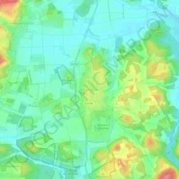
Name: Oberstetten topographic map, elevation, terrain.
Average elevation: 761 m
Minimum elevation: 732 m
Maximum elevation: 824 m
Make a donation
Other topographic maps
Click on a map to view its topography, its elevation and its terrain.
Eningen unter Achalm
Deutschland > Baden-Württemberg > Landkreis Reutlingen
Eningen liegt zwischen der Achalm und dem Albtrauf. Das Gemeindegebiet erstreckt sich über eine Höhe von 419 m bei der Straßenmeisterei bis 791 m beim Wolfsfelsen auf der Albhochfläche.
Average elevation: 528 m
Lichtenstein
Deutschland > Baden-Württemberg > Landkreis Reutlingen
Die Ortsteile Honau und Unterhausen liegen im Tal der Echaz, einem direkt unterhalb des Albtraufs in Honau entspringenden 23 Kilometer langen Nebenfluss des Neckars. Dagegen befindet sich der östliche Ortsteil Holzelfingen mit den etwas abgelegenen Weilern Göllesberg und dem zu Honau gehörenden Traifelberg…
Average elevation: 689 m
Römerstein
Deutschland > Baden-Württemberg > Landkreis Reutlingen
Die Gemeinde liegt etwa 22 Kilometer östlich von Reutlingen auf der Hochfläche der Schwäbischen Alb auf einer Höhe von 756 m ü. NHN (Böhringen) bis 803 m ü. NHN (Donnstetten). Sie ist nach der höchsten Erhebung des Gemeindegebiets, dem Römerstein (874,4 m ü. NHN), benannt.
Average elevation: 763 m
Gomadingen
Deutschland > Baden-Württemberg > Landkreis Reutlingen
Höhepunkt der Veranstaltungen in der Gemeinde Gomadingen sind die regelmäßig am letzten Wochenende im September und am ersten Wochenende im Oktober stattfindenden Hengstparaden in der 10.000 Zuschauer fassenden Arena im Haupt- und Landgestüt Marbach. Daneben ist das Anfang Mai stattfindende internationale…
Average elevation: 732 m
Make a donation
Bad Urach
Deutschland > Baden-Württemberg > Landkreis Reutlingen
Reichhaltige Funde auf dem Runden Berg bei Bad Urach belegen, dass dieser in der Spätantike/Frühmittelalter eine bedeutende alamannische Höhensiedlung und ein Machtzentrum der Alamannen war. Urach war Anfang des 12. Jahrhunderts Sitz eines von Egino I. gegründeten Grafengeschlechts. Die heutige Siedlung…
Average elevation: 668 m
Metzingen
Deutschland > Baden-Württemberg > Landkreis Reutlingen
Das Fabrikverkaufs-Gebiet am Rande der Innenstadt wird seit Beginn des 21. Jahrhunderts intensiv ergänzt und umgeordnet. Es stellt mittlerweile eine Mischung aus (teilweise renovierten) alten Industriegebäuden und modernen, sorgfältig gestalteten Neubauten mit puristischem „Fabrik-Charakter“ dar. Die…
Average elevation: 448 m
Make a donation
Reutlingen
Deutschland > Baden-Württemberg > Landkreis Reutlingen
Reutlingen liegt auf einer bis zu zwölf Meter starken, von Süden nach Norden geneigten Schotterterrasse an den Ufern der Echaz, die das Altstadtzentrum in einem leichten Bogen in tendenziell nordwestlicher Richtung umfließt. Das mittlere Vorland der Schwäbischen Alb rings um die Stadt erhebt sich westlich…
Average elevation: 488 m
Trochtelfingen
Deutschland > Baden-Württemberg > Landkreis Reutlingen
Trochtelfingen liegt im Tal des Flüsschens Seckach. Dieses mündet südlich der Stadt in die Lauchert. Die Gemarkung erstreckt sich über eine Höhenlage von 851,7 m ü. NHN im äußersten Westen im Gewann Kohlwald bis 673,4 m ü. NHN an der Lauchert beim Austritt aus dem Stadtgebiet.
Average elevation: 764 m
Sonnenbühl
Deutschland > Baden-Württemberg > Landkreis Reutlingen
Das Naturschutzgebiet Ruchberg liegt westlich von Willmandingen. Südwestlich von Erpfingen beginnt das Landschaftsschutzgebiet Laucherttal mit Nebentälern. Mit den Gebieten Salmendingen/Sonnenbühl, Albtrauf zwischen Mössingen und Gönningen und Albtrauf Pfullingen hat die Gemeinde Anteil an drei…
Average elevation: 754 m
Make a donation
Dettingen an der Erms
Deutschland > Baden-Württemberg > Landkreis Reutlingen
Die Gemarkung liegt im oberen Ermstal zwischen den Städten Metzingen und Bad Urach am Fuße der mittleren Schwäbischen Alb, der hier die Gemeindegrenze bildet, auf einer Höhe von 372 m ü. NN (Erms an der Gemarkungsgrenze zu Neuhausen an der Erms) bis 790 m ü. NN am Rossberg. Südlich von Dettingen…
Average elevation: 514 m
Make a donation
Schloss Pfullingen
Deutschland > Baden-Württemberg > Landkreis Reutlingen > Pfullingen
Average elevation: 457 m
Mägerkingen
Deutschland > Baden-Württemberg > Landkreis Reutlingen > Trochtelfingen
Average elevation: 760 m
Make a donation
Honau
Deutschland > Baden-Württemberg > Landkreis Reutlingen
Die Ortsteile Honau und Unterhausen liegen im Tal der Echaz, einem direkt unterhalb des Albtraufs in Honau entspringenden 23 Kilometer langen Nebenfluss des Neckars. Dagegen befindet sich der östliche Ortsteil Holzelfingen mit den etwas abgelegenen Weilern Göllesberg und dem zu Honau gehörenden Traifelberg…
Average elevation: 721 m
Bichishausen
Deutschland > Baden-Württemberg > Landkreis Reutlingen > Münsingen
Average elevation: 709 m
Hülben
Deutschland > Baden-Württemberg > Landkreis Reutlingen
Die Hülbener Tropfsteinhöhle ist eine am 19. September 1978 beim Ausbau der Landesstraße Bad Urach–Hülben entdeckte Tropfsteinhöhle mit Stalaktiten und Stalagmiten. Der Einstieg in das Naturdenkmal befindet sich an der Landesstraße nach Bad Urach kurz oberhalb des Gebäudes An der Steige 10. Durch…
Average elevation: 666 m
Make a donation
72581
Deutschland > Baden-Württemberg > Landkreis Reutlingen > Dettingen an der Erms
Average elevation: 545 m
Walddorf
Deutschland > Baden-Württemberg > Landkreis Reutlingen
Walddorfhäslach liegt am Rande des Naturparks Schönbuch. Das Gemeindegebiet erstreckt sich über eine Höhenlage von 336 m ü. NN im Schaichtal bis 501 m ü. NN auf der Walddorfer Platte.
Average elevation: 408 m
Make a donation
Rommelsbach
Deutschland > Baden-Württemberg > Landkreis Reutlingen > Reutlingen
Average elevation: 363 m
Reutlingen-Betzingen
Deutschland > Baden-Württemberg > Landkreis Reutlingen > Reutlingen
Average elevation: 376 m
Make a donation
Sondelfingen
Deutschland > Baden-Württemberg > Landkreis Reutlingen > Reutlingen
Average elevation: 403 m
Oferdingen
Deutschland > Baden-Württemberg > Landkreis Reutlingen > Reutlingen
Average elevation: 343 m
Waldsiedlung Beerenhalde
Deutschland > Baden-Württemberg > Landkreis Reutlingen > Sonnenbühl
Average elevation: 773 m
Reicheneck
Deutschland > Baden-Württemberg > Landkreis Reutlingen > Reutlingen
Average elevation: 360 m
Make a donation
Biosphärengebiet Schwäbische Alb (Kernzone)
Deutschland > Baden-Württemberg > Landkreis Reutlingen > Gomadingen
Average elevation: 649 m
Make a donation
Unterhausen
Deutschland > Baden-Württemberg > Landkreis Reutlingen > Unterhausen
Average elevation: 670 m
Würtingen
Deutschland > Baden-Württemberg > Landkreis Reutlingen > St. Johann
Average elevation: 684 m
Make a donation
Willmandingen
Deutschland > Baden-Württemberg > Landkreis Reutlingen
Das Naturschutzgebiet Ruchberg liegt westlich von Willmandingen. Südwestlich von Erpfingen beginnt das Landschaftsschutzgebiet Laucherttal mit Nebentälern. Mit den Gebieten Salmendingen/Sonnenbühl, Albtrauf zwischen Mössingen und Gönningen und Albtrauf Pfullingen hat die Gemeinde Anteil an drei…
Average elevation: 768 m
Gundelfingen
Deutschland > Baden-Württemberg > Landkreis Reutlingen > Münsingen
Average elevation: 715 m
Make a donation
Hundersingen
Deutschland > Baden-Württemberg > Landkreis Reutlingen > Münsingen
Average elevation: 726 m
Make a donation
Ableitung Erms
Deutschland > Baden-Württemberg > Landkreis Reutlingen > Dettingen an der Erms
Average elevation: 482 m
Altenburg
Deutschland > Baden-Württemberg > Landkreis Reutlingen > Reutlingen
Die auf der Anhöhe am Nordende des Dorfes stehende Kirche wurde 1654, anstelle einer dem heiligen Nikolaus durch Bischof Werner von Straßburg geweihten Kapelle, errichtet. Ihr heutiger Bau entstammt teilweise dem 11. Jahrhundert. Beide Glocken wurden 1837 von Christian Adam Kurtz und Sohn in Reutlingen…
Average elevation: 354 m
Make a donation
Sirchingen
Deutschland > Baden-Württemberg > Landkreis Reutlingen > Bad Urach
Average elevation: 694 m
72818
Deutschland > Baden-Württemberg > Landkreis Reutlingen > Trochtelfingen > Steinhilben
Average elevation: 780 m
Engstingen
Deutschland > Baden-Württemberg > Landkreis Reutlingen
Engstingen liegt am Nordrand der Schwäbischen Alb im Bereich der Mittleren Kuppenalb, in 680 bis 750 Meter Höhe auf der Albhochfläche oberhalb des Albtraufs. Es liegt im Tal der Ur-Lauter, etwa 15 km Luftlinie südlich der Kreisstadt Reutlingen.
Average elevation: 735 m
Make a donation
Genkingen
Deutschland > Baden-Württemberg > Landkreis Reutlingen
Das Naturschutzgebiet Ruchberg liegt westlich von Willmandingen. Südwestlich von Erpfingen beginnt das Landschaftsschutzgebiet Laucherttal mit Nebentälern. Mit den Gebieten Salmendingen/Sonnenbühl, Albtrauf zwischen Mössingen und Gönningen und Albtrauf Pfullingen hat die Gemeinde Anteil an drei…
Average elevation: 737 m
Hohenstein
Deutschland > Baden-Württemberg > Landkreis Reutlingen
Die Gemeinde liegt in 720 bis 830 Meter Höhe auf der so genannten Mittleren Kuppenalb. Diese ist gekennzeichnet durch Trockentäler mit Wacholderheiden und sanften bewaldeten Hügeln.
Average elevation: 750 m
Buttenhausen
Deutschland > Baden-Württemberg > Landkreis Reutlingen > Münsingen
Average elevation: 743 m
Make a donation
Riedrichbach
Deutschland > Baden-Württemberg > Landkreis Reutlingen > Metzingen
Average elevation: 404 m
Reutlingen
Deutschland > Baden-Württemberg > Landkreis Reutlingen
Reutlingen liegt auf einer bis zu zwölf Meter starken, von Süden nach Norden geneigten Schotterterrasse an den Ufern der Echaz, die das Altstadtzentrum in einem leichten Bogen in tendenziell nordwestlicher Richtung umfließt. Das mittlere Vorland der Schwäbischen Alb rings um die Stadt erhebt sich westlich…
Average elevation: 488 m
Bad Urach
Deutschland > Baden-Württemberg > Landkreis Reutlingen
Die höchste Stelle im Stadtgebiet Bad Urachs liegt auf 789,34 m ü. NHN, auf einer unbenannten Kuppe an der westlichen Stadtgrenze zu St. Johann, ungefähr 1000 m westsüdwestlich vom Uracher Wasserfall. Die tiefste Stelle im Stadtgebiet ist mit einer Höhe von 417,9 m ü. NHN der Ort, an dem die Erms das…
Average elevation: 668 m
Make a donation
Eningen unter Achalm
Deutschland > Baden-Württemberg > Landkreis Reutlingen
Eningen liegt zwischen der Achalm und dem Albtrauf. Das Gemeindegebiet erstreckt sich über eine Höhe von 402,1 m ü. NHN beim Südbahnhof bis 792 m ü. NHN beim Wolfsfelsen auf der Albhochfläche.
Average elevation: 532 m
Sonnenbühl
Deutschland > Baden-Württemberg > Landkreis Reutlingen
Das Naturschutzgebiet Ruchberg liegt westlich von Willmandingen. Südwestlich von Erpfingen beginnt das Landschaftsschutzgebiet Laucherttal mit Nebentälern. Mit den Gebieten Salmendingen/Sonnenbühl, Albtrauf zwischen Mössingen und Gönningen und Albtrauf Pfullingen hat die Gemeinde Anteil an drei…
Average elevation: 754 m
Make a donation
Hülben
Deutschland > Baden-Württemberg > Landkreis Reutlingen
Die Hülbener Tropfsteinhöhle ist eine am 19. September 1978 beim Ausbau der Landesstraße Bad Urach–Hülben entdeckte Tropfsteinhöhle mit Stalaktiten und Stalagmiten. Der Einstieg in das Naturdenkmal befindet sich an der Landesstraße nach Bad Urach kurz oberhalb des Gebäudes An der Steige 10. Durch…
Average elevation: 666 m
Römerstein
Deutschland > Baden-Württemberg > Landkreis Reutlingen
Die Gemeinde liegt etwa 22 Kilometer östlich von Reutlingen auf der Hochfläche der Schwäbischen Alb auf einer Höhe von 756 m ü. NHN (Böhringen) bis 803 m ü. NHN (Donnstetten). Sie ist nach der höchsten Erhebung des Gemeindegebiets, dem Römerstein (874,4 m ü. NHN), benannt.
Average elevation: 763 m
Make a donation
Sonnenbühl
Deutschland > Baden-Württemberg > Landkreis Reutlingen
Das Naturschutzgebiet Ruchberg liegt westlich von Willmandingen. Südwestlich von Erpfingen beginnt das Landschaftsschutzgebiet Laucherttal mit Nebentälern. Mit den Gebieten Salmendingen/Sonnenbühl, Albtrauf zwischen Mössingen und Gönningen und Albtrauf Pfullingen hat die Gemeinde Anteil an drei…
Average elevation: 754 m