
Switzerland topographic map
Interactive map
Click on the map to display elevation.
Switzerland
Switzerland lies between latitudes 45° and 48° N, and longitudes 5° and 11° E. It contains three basic topographical areas: the Swiss Alps to the south, the Swiss Plateau or Central Plateau, and the Jura mountains on the west. The Alps are a high mountain range running across the central-south of the country, constituting about 60% of the country's total area. The majority of the Swiss population live in the Swiss Plateau. Among the high valleys of the Swiss Alps many glaciers are found, totalling an area of 1,063 square kilometres (410 sq mi). From these originate the headwaters of several major rivers, such as the Rhine, Inn, Ticino and Rhône, which flow in the four cardinal directions into the whole of Europe. The hydrographic network includes several of the largest bodies of freshwater in Central and Western Europe, among which are included Lake Geneva (also called le Lac Léman in French), Lake Constance (known as Bodensee in German) and Lake Maggiore. Switzerland has more than 1500 lakes, and contains 6% of Europe's stock of fresh water. Lakes and glaciers cover about 6% of the national territory. The largest lake is Lake Geneva, in western Switzerland shared with France. The Rhône is both the main source and outflow of Lake Geneva. Lake Constance is the second largest Swiss lake and, like the Lake Geneva, an intermediate step by the Rhine at the border to Austria and Germany. While the Rhône flows into the Mediterranean Sea at the French Camargue region and the Rhine flows into the North Sea at Rotterdam in the Netherlands, about 1,000 kilometres (620 miles) apart, both springs are only about 22 kilometres (14 miles) apart from each other in the Swiss Alps.
About this map
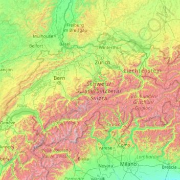
Name: Switzerland topographic map, elevation, terrain.
Location: Switzerland (45.81796 5.95591 47.80845 10.49229)
Average elevation: 1,016 m
Minimum elevation: 41 m
Maximum elevation: 4,564 m
Other topographic maps
Click on a map to view its topography, its elevation and its terrain.
Istanbul
Istanbul, located in northwestern Turkey, is a city that is uniquely situated across two continents, Europe and Asia, divided by the Bosphorus Strait. The city’s topography is characterized by a complex blend of hills, valleys, and coastal plains, which create a varied and scenic landscape. The European side…
Average elevation: 57 m
Atacama Desert
Chile > Antofagasta Region > Provincia de Antofagasta > Antofagasta
The Coastal Cliff of northern Chile west of the Chilean Coast Range is the main topographical feature of the coast. The geomorphology of the Atacama Desert has been characterized as a low-relief bench "similar to a giant uplifted terrace" by Armijo and co-workers. The intermediate depression (or Central…
Average elevation: 1,961 m
Mount Judi
The Arabic word al-Jūdiyy (ٱلْجُودِيّ), originates from the Syriac word Gudo (ܓܘܕܐ) meaning "Mounds" or "Elevations". The relation of some of the spellings is clear. The origin of Judi is less clear. It is usually interpreted as a corrupted version of the same name, via Al-Gurdi (Reynolds 2004).…
Average elevation: 1,904 m
Chiang Mai
Chiang Mai has a tropical savanna climate (Köppen Aw), tempered by the low latitude and moderate elevation, with warm to hot weather year-round, though nighttime conditions during the dry season can be cool and much lower than daytime highs. The maximum temperature ever recorded was 42.4 °C (108.3 °F) in…
Average elevation: 424 m
Himalayas
The Himalayas, or Himalaya (/ˌhɪməˈleɪ.ə, hɪˈmɑːləjə/ HIM-ə-LAY-ə, hih-MAH-lə-yə), is a mountain range in Asia, separating the plains of the Indian subcontinent from the Tibetan Plateau. The range has some of the Earth's highest peaks, including the highest, Mount Everest. More than 100 peaks…
Average elevation: 2,385 m
Rocky Mountains
Canada > British Columbia > Peace River Regional District > Area D (Kiskatinaw Valley)
Average elevation: 1,252 m
Frills Corners
United States > Pennsylvania > Clarion County > Washington Township
Average elevation: 482 m
Bangladesh
With an elevation of 1,064 m (3,491 ft), Saka Haphong (also known as Mowdok Mual) near the border with Myanmar, is claimed to be the highest peak of Bangladesh. However, it is not yet widely recognized as the highest point of the country, and most sources give the honor to Keokradong.
Average elevation: 1,488 m
Sunset Peak
Sunset Peak is only accessible by foot. It is located on section 2 of the 70 km (43 mi) long Lantau Trail. Section 2 is 6.5 km long and goes from Nam Shan Campsite west of Mui Wo on South Lantau Road (elevation about 120 m), to Pak Kung Au, another campsite on the Tung Chung Road (elevation about 340 m). Both…
Average elevation: 411 m
Huế
The Perfume River (called Sông Hương or Hương Giang in Vietnamese) passes through the center of province. The province also accommodates the Tam Giang–Cau Hai lagoon, the largest lagoon in Southeast Asia, which is 68 kilometres (42 mi) long with a surface area of 220 square kilometres (85 sq mi). The…
Average elevation: 30 m
Augustine Volcano
United States > Alaska > Kenai Peninsula Borough
The nearly circular uninhabited island formed by Augustine Volcano is 12 km (7.5 mi) wide east–west, 10 km (6.2 mi) north-south; a nearly symmetrical central summit peaks at altitude 4,134 feet (1,260 m).
Average elevation: 658 m
Chitral
Pakistan > Khyber Pakhtunkhwa > Chitrāl District
The city has an average elevation of 1,500 m (4,921 ft).
Average elevation: 2,982 m
Mount Apo
Philippines > Davao del Sur > Bansalan
Mount Apo is the highest mountain peak in the Philippines, with an elevation of 2,954 meters (9,692 ft) above sea level. A large solfataric, dormant stratovolcano, it is part of the Apo-Talomo Mountain Range of Mindanao island. Apo is situated on the tripartite border of Davao City, Davao del Sur, and…
Average elevation: 2,416 m
Ilagan
Abuan River is the main river of the Northern Sierra Madre Natural Park. It has an average elevation of 82 meters above sea level, and feeds the Abuan watershed in the city. Tourists and visitors can explore the diverse animal and plant life in one of the country’s remaining lush virgin forests. On January…
Average elevation: 123 m
Amman
Jordan > Amman > Amman Sub-District
Amman is situated on the East Bank Plateau, an upland characterized by three major wadis which run through it. Originally, the city had been built on seven hills. Amman's terrain is typified by its mountains. The most important areas in the city are named after the hills or mountains they lie on. The area's…
Average elevation: 800 m
Croydon
Several apartment developments, for instance Altitude 25 (completed 2010), have been built in recent years, and several more are being built or planned. The construction of Saffron Square, which includes a 43-storey tower, began on Wellesley Road in 2011 and was completed in 2016. Other developments with…
Average elevation: 70 m
Balfour
Canada > British Columbia > Regional District of Central Kootenay > Area E (Balfour/Cottonwood Lake)
Average elevation: 673 m
Peterborough
United Kingdom > England > Cambridgeshire
The cathedral city of Ely is 24 miles (39 km) east-southeast across the Fens and the university city of Cambridge is 30 miles (48 km) to the southeast. The local topography is flat, and in places, the land lies below sea level.
Average elevation: 17 m
Dehradun
India > Uttarakhand > Dehradun
The city of Dehradun mainly lies in Doon Valley and is at a varying height from 410 m (1,350 ft) in Clement Town to above 700 m (2,300 ft) at Malsi which is 15 km (9.3 mi) from the city. However, the average elevation is 450 m (1,480 ft) above sea level. Malsi is the starting point of Lesser Himalayan Range…
Average elevation: 904 m
Ben Nevis
United Kingdom > Scotland > Highland
Ben Nevis has a highland tundra climate (ET in the Köppen classification). Ben Nevis's elevation, maritime location and topography frequently lead to cool and cloudy weather conditions, which can pose a danger to ill-equipped walkers. According to the observations carried out at the summit observatory from…
Average elevation: 912 m
Verdin
France > Bourgogne – Franche-Comté > Saône-et-Loire > Montagny-près-Louhans
Average elevation: 199 m
Snowdon
United Kingdom > Wales > Gwynedd
Snowdon (/ˈsnoʊdən/), or Yr Wyddfa (Welsh: [ər ˈʊɨ̞̯ðva] ), is a mountain in Snowdonia in North Wales. It has an elevation of 1,085 metres (3,560 ft) above sea level, which makes it both the highest mountain in Wales and the highest in the British Isles south of the Scottish Highlands. Snowdon is…
Average elevation: 692 m