
Southeast Sulawesi topographic map
Interactive map
Click on the map to display elevation.
About this map
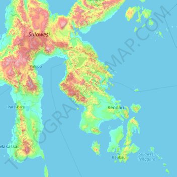
Name: Southeast Sulawesi topographic map, elevation, terrain.
Location: Southeast Sulawesi, Indonesia (-6.14912 119.12796 -0.94912 124.32796)
Average elevation: 232 m
Minimum elevation: -2 m
Maximum elevation: 3,227 m
Other topographic maps
Click on a map to view its topography, its elevation and its terrain.
Pulau Bali
Bali's central mountains include several peaks over 2,000 metres (6,600 feet) in elevation and active volcanoes such as Mount Batur. The highest is Mount Agung (3,031 m; 9,944 ft), known as the "mother mountain", which is an active volcano rated as one of the world's most likely sites for a massive eruption…
Average elevation: 122 m
Bromo Tengger Semeru National Park
Indonesia > East Java > Kabupaten Malang
Bromo Tengger Semeru National Park (Indonesian: Taman Nasional Bromo Tengger Semeru; abbreviated as TNBTS) is a national park located in East Java, Indonesia, to the east of Malang and Lumajang, to the south of Pasuruan and Probolinggo, and to the southeast of Surabaya, the capital of East Java. It is the only…
Average elevation: 1,343 m
Lake Toba
Lake Toba (Indonesian: Danau Toba, Toba Batak: ᯖᯀᯬ ᯖᯬᯅ; romanized: Tao Toba) is a large natural lake in North Sumatra, Indonesia, occupying the caldera of the Toba supervolcano. The lake is located in the middle of the northern part of the island of Sumatra, with a surface elevation of about 900…
Average elevation: 1,079 m
Bogor
The city is situated in the western part of Java island, about 53 km south of the metropolis of Jakarta and 85 km northwest of the city of Bandung, the administrative center of West Java Province. Bogor spreads over a basin near the volcanoes of Salak (which peaks at about 12 km south) and Mount Gede (whose…
Average elevation: 310 m
Tulungagung
Topographically, Tulungagung Regency is located 85 m (279 ft) above the sea level. The northwest part of the regency is a portion of the Wilis-Liman mountain range; the central part is lowland; the southern part is a portion of the rocky Kapur Kidul mountain range which is also an enormous source of marble. In…
Average elevation: 263 m
Sukabumi
At an altitude of approximately 584 m (1,916 ft), the city is a minor hill station resort, with a cooler climate than the surrounding lowlands. The area around Sukabumi is also a popular destination for whitewater rafting. Tea and Rubber production is a major industry in the area. The suburban area surrounding…
Average elevation: 570 m
Riau
In general, the geography of Riau consists of mountains, lowlands, and islands. The mountain area lies in the western part, namely the Bukit Barisan Mountains, near the border of West Sumatra. The elevation decreases towards the east, making most of the central and eastern part of the province covered with…
Average elevation: 115 m
Natuna
The airport resides at an elevation of 2 metres (6 ft 7 in) above mean sea level. It has one runway designated 18/36 with an asphalt surface measuring 2,560 m x 32 m (8,399 ft × 105 ft). The runway is planned to be widened to 80 m in 2020. Moreover, the airport has an apron measuring 120 m x 60 m and a…
Average elevation: 1 m
Tabanan
Jatiluwih village in Penebel District, north of Tabanan, has paddy fields following the contours of terraced land against the background of spellbinding Mount Batukaru and Mount Agung use traditional Balinese irrigation known as subak, Bali's community-based water control management system. Lies at an altitude…
Average elevation: 450 m
Bali
Bali's central mountains include several peaks over 2,000 metres (6,600 feet) in elevation and active volcanoes such as Mount Batur. The highest is Mount Agung (3,031 m, 9,944 ft), known as the "mother mountain", which is an active volcano rated as one of the world's most likely sites for a massive eruption…
Average elevation: 88 m