
Make a donation
Anshan City topographic map
Click on the map to display elevation.
Make a donation
Anshan City
Local transportation is primarily by bus or taxi. Anshan used to have a single tram line—along Zhonghua Avenue, through the city centre and past Angang main gate—but this has been closed and the tracks removed. Due to the flat topography of the city centre, bicycles are popular. Almost all roads have a wide cycle lane on each side. Often this lane is further protected by a traffic island that separates the bikes from larger motor vehicles.
Make a donation
About this map
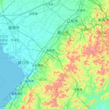
Name: Anshan City topographic map, elevation, terrain.
Location: Anshan City, Liaoning, China (39.99865 122.18702 41.56818 123.76188)
Average elevation: 145 m
Minimum elevation: -2 m
Maximum elevation: 1,111 m
Make a donation
Other topographic maps
Click on a map to view its topography, its elevation and its terrain.