
常德市 topographic map
Interactive map
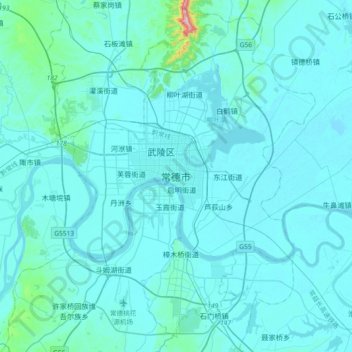
Click on the map to display elevation.
About this map
Name: 常德市 topographic map, elevation, terrain.
Location: 常德市, 湖南省, 415099, 中国 (28.87455 111.53287 29.19455 111.85287)
Average elevation: 49 m
Minimum elevation: 23 m
Maximum elevation: 533 m
常德地貌以平原为主。境内山水相连,地势西北高东南低。西部有“湖南屋脊”之称的壶瓶山。东南部是地肥水美的西洞庭湖平原,平均海拔在50米以下。中部过渡地段为丘陵。湖南四大水系中的沅江和澧水流经常德,境内有大小河流432条。平湖区江河纵横,水网密布,有广阔的天然湿地。
Other topographic maps
Click on a map to view its topography, its elevation and its terrain.