
King George Island topographic map
Interactive map
Click on the map to display elevation.
About this map
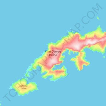
Name: King George Island topographic map, elevation, terrain.
Location: King George Island, 20001-971 (-62.26287 -59.03399 -61.88936 -57.57724)
Average elevation: 53 m
Minimum elevation: 0 m
Maximum elevation: 692 m
Other topographic maps
Click on a map to view its topography, its elevation and its terrain.
Bangladesh
With an elevation of 1,064 m (3,491 ft), Saka Haphong (also known as Mowdok Mual) near the border with Myanmar, is claimed to be the highest peak of Bangladesh. However, it is not yet widely recognized as the highest point of the country, and most sources give the honor to Keokradong.
Average elevation: 1,488 m
Istanbul
Because of its hilly topography and maritime influences, Istanbul exhibits a multitude of distinct microclimates. Within the city, rainfall varies widely owing to the rain shadow of the hills in Istanbul, from around 600 millimeters (24 in) on the southern fringe at Florya to 1,200 millimeters (47 in) on the…
Average elevation: 57 m
Village of Woodbury
United States > New York > Orange County > Town of Woodbury
Average elevation: 255 m
Salta
Salta has a subtropical highland climate (Cwb, according to the Köppen climate classification), and it is characterized by pleasant weather year-round. Located in the subtropical north, but at an altitude of 1,200 metres, Salta enjoys 4 distinct seasons: summers are warm with frequent thunderstorms, with…
Average elevation: 1,270 m
Chiang Mai
Chiang Mai has a tropical savanna climate (Köppen Aw), tempered by the low latitude and moderate elevation, with warm to hot weather year-round, though nighttime conditions during the dry season can be cool and much lower than daytime highs. The maximum temperature ever recorded was 42.4 °C (108.3 °F) in…
Average elevation: 424 m
Sweden
At 449,964 km2 (173,732 sq mi), Sweden is the 55th-largest country in the world, the fifth-largest country in Europe, and the largest country in Northern Europe. The lowest elevation in Sweden is in the bay of Lake Hammarsjön, near Kristianstad, at −2.41 m (−7.91 ft) below sea level. The highest point is…
Average elevation: 163 m
Las Vegas
United States > Nevada > Clark County
The city's elevation is approximately 2,030 ft (620 m) above sea level, though the surrounding peaks reach elevations of over 10,000 feet (3,000 m) and act as barriers to the strong flow of moisture from the surrounding area. According to the United States Census Bureau, the city has an area of 135.86 sq mi…
Average elevation: 756 m
Yunnan
Yunnan is situated in a mountainous area, with high elevations in the Northwest and low elevations in the Southeast. Most of the population lives in the eastern part of the province. In the west, the altitude can vary from the mountain peaks to river valleys as much as 3,000 m (9,800 ft). Yunnan is rich in…
Average elevation: 1,713 m
Ayder
Ayder at 40°57′N 41°05′E / 40.950°N 41.083°E / 40.950; 41.083 is a typical yayla with no settled population; it hosts visitors during summers. The average altitude is 1,350 metres (4,430 ft). It is a part of Çamlıhemşin District of Rize Province. The distance to Çamlıhemşin is 17…
Average elevation: 1,683 m
Astana
Astana is located in central Kazakhstan on the Ishim River in a very flat, semi-arid steppe region which covers most of the country's territory. It is at 51° 10' north latitude and 71° 26' east longitude. The city encompasses 722.0 square kilometres (278.8 sq mi). The elevation of Astana is 347 metres (1,138…
Average elevation: 361 m
California
California's mountains produce rain shadows on the eastern side, creating extensive deserts. The higher elevation deserts of eastern California have hot summers and cold winters, while the low deserts east of the Southern California mountains have hot summers and nearly frostless mild winters. Death Valley, a…
Average elevation: 929 m
Gqeberha
South Africa > Eastern Cape > Nelson Mandela Bay Metropolitan Municipality
Average elevation: 37 m
Arrowhead Estates
United States > South Dakota > Pennington County > Rapid City
Average elevation: 1,116 m