
Make a donation
California topographic map
Click on the map to display elevation.
Make a donation
California
California's topography is characterized by a remarkable diversity that includes expansive mountain ranges, deep valleys, and vast deserts. The Sierra Nevada mountains dominate the eastern part of the state, with peaks such as Mount Whitney rising to 14,494 feet (4,418 meters), making it the tallest point in the contiguous United States. This range features steep, rugged terrain and glacial valleys, exemplified by the iconic Yosemite Valley. In contrast, the Central Valley, stretching approximately 450 miles (724 kilometers) between the Sierra Nevada and the Coastal Ranges, offers a broad and fertile plain that is vital for agriculture. The Coastal Ranges, which run parallel to the Pacific coast, are home to a mix of rugged hills and rich valleys, including the famous Napa Valley. To the southeast, the Basin and Range province encompasses arid deserts, including Death Valley, which is notable for being the lowest point in North America at 282 feet (86 meters) below sea level. This varied landscape contributes to California's unique ecosystems and climatic conditions, making it one of the most geologically diverse states in the U.S.
Make a donation
About this map
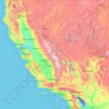
Name: California topographic map, elevation, terrain.
Location: California, United States (32.52952 -124.48200 42.00950 -114.13078)
Average elevation: 929 m
Minimum elevation: -82 m
Maximum elevation: 4,095 m
Make a donation
Other topographic maps
Click on a map to view its topography, its elevation and its terrain.
Cajon Pass
United States > California > San Bernardino County
Cajon Pass (/kəˈhoʊn/; Spanish: Puerto del Cajón or Paso del Cajón) is a mountain pass between the San Bernardino Mountains to the east and the San Gabriel Mountains to the west in Southern California. Created by the movements of the San Andreas Fault, it has an elevation of 3,777 ft (1,151 m). Located in…
Average elevation: 1,169 m
Elmhurst
United States > Illinois > DuPage County
Due to local topography, the town has had a tendency to flood in the past after large rainfalls; the city is currently undertaking a large effort to mitigate future flooding.
Average elevation: 207 m
Make a donation
Flagstaff
United States > Arizona > Coconino County
Flagstaff is the county seat of Coconino County. According to the United States Census Bureau, the city has a total area of 63.9 square miles (165.5 km2), of which only 0.03 square miles (0.08 km2) (0.08%) is water. Flagstaff lies at approximately 7,000 feet (2,130 m) elevation, and is surrounded by the…
Average elevation: 2,176 m
Bowles
United States > California > Fresno County
Bowles is a census-designated place (CDP) in Fresno County, California, United States. The population was 166 at the 2010 census, down from 182 at the 2000 census. Bowles is located 11 miles (18 km) south of downtown Fresno, at an elevation of 279 feet (85 m).
Average elevation: 86 m
Make a donation
Make a donation
Arrowhead Estates
United States > South Dakota > Pennington County > Rapid City
Average elevation: 1,116 m
Make a donation
Make a donation
Make a donation
Make a donation
Make a donation
Make a donation
Make a donation
Make a donation
Brentwood
United States > California > Contra Costa County > Brentwood > Brentwood
Average elevation: 27 m
Cleveland
United States > Ohio > Cuyahoga County > Cleveland
The land rises quickly from the lake shore elevation of 569 feet. Public Square, less than one mile (1.6 km) inland, sits at an elevation of 650 feet (198 m), and Hopkins Airport, 5 miles (8 km) inland from the lake, is at an elevation of 791 feet (241 m).
Average elevation: 221 m
Jacksonville
United States > Florida > Duval County > Jacksonville
Just south of Jacksonville and north of Saint Augustine is the boundary of where the Floridian Peninsula ends and Continental North America begins; Jacksonville is north of that line. While still in the North American Coastal plain, the topography begins to take on slight Piedmont characteristics. Like the…
Average elevation: 9 m
Make a donation
Oakwood Park
United States > New Jersey > Union County > New Providence > Oakwood Park
Average elevation: 87 m
Highland Woods Golf & Country Club
United States > Florida > Lee County > Bonita Springs
Average elevation: 5 m
Colorado Springs
United States > Colorado > El Paso County
Snowfall is usually moderate and remains on the ground briefly because of direct sun, with the city receiving 38 inches (97 cm) per season, although the mountains to the west often receive in excess of triple that amount; March is the snowiest month in the region, both by total accumulation and number of days…
Average elevation: 2,229 m
Make a donation
Mississippi River
United States > Louisiana > West Feliciana Parish
The uppermost lock and dam on the Upper Mississippi River is the Upper St. Anthony Falls Lock and Dam in Minneapolis. Above the dam, the river's elevation is 799 feet (244 m). Below the dam, the river's elevation is 750 feet (230 m). This 49-foot (15 m) drop is the largest of all the Mississippi River locks…
Average elevation: 13 m
Make a donation