
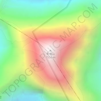
贡嘎山 topographic map
Interactive map
Click on the map to display elevation.
About this map
Name: 贡嘎山 topographic map, elevation, terrain.
Location: 贡嘎山, 泸定县, 甘孜藏族自治州, 四川省, 626100, 中国 (29.59580 101.87901 29.59590 101.87911)
Average elevation: 6,496 m
Minimum elevation: 5,699 m
Maximum elevation: 7,468 m
贡嘎山(藏文:མི་ཉག་གངས་དཀར་རི་བོ་,康方言拼音方案:Mi'nyâg Gong'ga Riwo)是位于中国四川省甘孜藏族自治州康定市、泸定县及雅安市石棉县之间的一座山。一般认为,贡嘎山指的是一个包含了若干座山峰的山块;狭义上则特指其中的最高峰木雅贡嘎山(或直称贡嘎山,英语:Minya Konka,或汉语拼音:Gongga Shan),海拔7,514.96±0.97米。
Other topographic maps
Click on a map to view its topography, its elevation and its terrain.