
磨西镇 topographic map
Interactive map
Click on the map to display elevation.
About this map
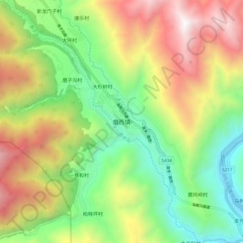
Name: 磨西镇 topographic map, elevation, terrain.
Location: 磨西镇, 泸定县, 甘孜藏族自治州, 四川省, 626100, 中国 (29.60253 102.08386 29.68253 102.16386)
Average elevation: 2,063 m
Minimum elevation: 1,118 m
Maximum elevation: 3,411 m
磨西镇位于中国四川省甘孜州泸定县中部,贡嘎山东麓,海拔约1600米。“磨西”为古羌语,意为“宝地”。
Other topographic maps
Click on a map to view its topography, its elevation and its terrain.