
睢县 topographic map
Interactive map
Click on the map to display elevation.
About this map
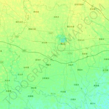
Name: 睢县 topographic map, elevation, terrain.
Location: 睢县, 商丘市, 河南省, 中国 (34.20491 114.84299 34.57527 115.20653)
Average elevation: 57 m
Minimum elevation: 50 m
Maximum elevation: 64 m
睢县位处豫东平原,为黄河下游冲积扇一部分。总的地形平坦,西北略高,东南略低,西北与东南之间的高差为9米。境内河流有惠济河、通惠渠等。城内有北湖及周围五个卫星湖,全县湿地总面积2112公顷,有“中原水城”之称。
Other topographic maps
Click on a map to view its topography, its elevation and its terrain.