
Little Mount Anglem topographic map
Interactive map
Click on the map to display elevation.
About this map
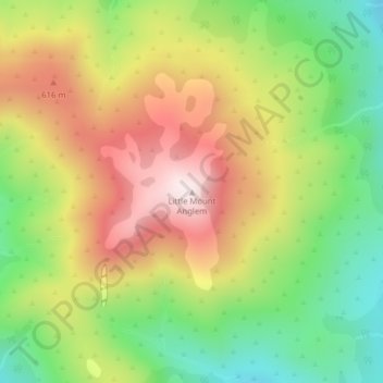
Name: Little Mount Anglem topographic map, elevation, terrain.
Location: Little Mount Anglem, Southland, New Zealand (-46.76816 167.95103 -46.76806 167.95113)
Average elevation: 442 m
Minimum elevation: 181 m
Maximum elevation: 735 m
Other topographic maps
Click on a map to view its topography, its elevation and its terrain.
Opononi
New Zealand > Northland > Far North District > Kaikohe-Hokianga Community
Average elevation: 51 m
Wellington
New Zealand > Wellington > Wellington City
Averaging 2,055 hours of sunshine per year, the climate of Wellington is temperate marine, (Köppen: Cfb), generally moderate all year round with warm summers and mild winters, and rarely sees temperatures above 26 °C (79 °F) or below 4 °C (39 °F). The hottest recorded temperature in the city is 31.1 °C…
Average elevation: 85 m