
Rahu River topographic map
Interactive map
Click on the map to display elevation.
About this map
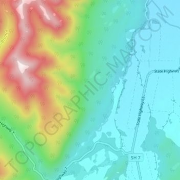
Name: Rahu River topographic map, elevation, terrain.
Location: Rahu River, Buller District, West Coast, New Zealand (-42.34244 172.12314 -42.29201 172.18940)
Average elevation: 636 m
Minimum elevation: 395 m
Maximum elevation: 1,291 m
Other topographic maps
Click on a map to view its topography, its elevation and its terrain.
Mount Ruapehu
New Zealand > Manawatū-Whanganui > Ruapehu District
Ruapehu has a polar tundra climate (Köppen: ET) on the upper slopes, with average temperatures ranging from −4–15 °C in summer and −7–7 °C in winter, depending on elevation and cloudiness. On the lower slopes, Ruapehu has a subpolar oceanic climate (Köppen: Cfc).
Average elevation: 2,474 m
Opononi
New Zealand > Northland > Far North District > Kaikohe-Hokianga Community
Average elevation: 51 m