
Make a donation
Disappointment Island topographic map
Click on the map to display elevation.
Make a donation
About this map
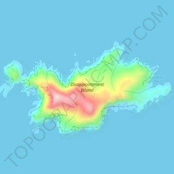
Name: Disappointment Island topographic map, elevation, terrain.
Location: Disappointment Island, New Zealand (-50.61368 165.94857 -50.59750 165.99633)
Average elevation: 29 m
Minimum elevation: -5 m
Maximum elevation: 302 m
Make a donation
Other topographic maps
Click on a map to view its topography, its elevation and its terrain.
Mount Ruapehu
New Zealand > Manawatū-Whanganui > Ruapehu District
Ruapehu has a polar tundra climate (Köppen: ET) on the upper slopes, with average temperatures ranging from −4–15 °C in summer and −7–7 °C in winter, depending on elevation and cloudiness. On the lower slopes, Ruapehu has a subpolar oceanic climate (Köppen: Cfc).
Average elevation: 2,474 m
Opononi
New Zealand > Northland > Far North District > Kaikohe-Hokianga Community
Average elevation: 51 m
Make a donation