
福清市 topographic map
Interactive map
Click on the map to display elevation.
About this map
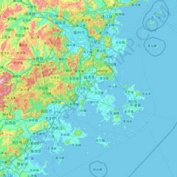
Name: 福清市 topographic map, elevation, terrain.
Location: 福清市, 福建省, 中国 (24.93015 118.67564 26.33015 120.07564)
Average elevation: 147 m
Minimum elevation: -4 m
Maximum elevation: 1,502 m
福清位于福州东南部,福建中部沿海。全境分大陆、半岛和岛屿三个部分。总面积2,429.76平方千米,其中陆地1,518.24平方千米,平原总面积为375平方千米,海域911.52平方千米,大小岛礁866个。市中心纬度: 25°43'21.85"N , 经度:119°22'38.29"E。东部与平潭县相望,南部莆田市涵江区,西部与永泰县,北部与福州市长乐区和闽侯县分别接壤,全境地势西高东低。福清境内最高峰是西北部一都镇的古崖山尾,海拔1,003米。海岸线漫长曲折,北起城头镇,南至新厝镇,总长348公里,多属基岩海岸。
Other topographic maps
Click on a map to view its topography, its elevation and its terrain.
武夷山国家级风景名胜区
武夷山国家级风景名胜区, 武夷街道, 武夷山市, 南平市, 福建省, 354300, 中国
Average elevation: 302 m