
董奉山国家森林公园 topographic map
Interactive map
Click on the map to display elevation.
About this map
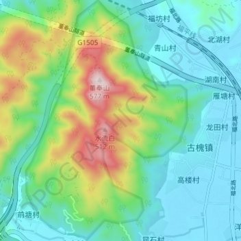
Name: 董奉山国家森林公园 topographic map, elevation, terrain.
Location: 董奉山国家森林公园, 长乐区, 福州市, 福建省, 中国 (25.86270 119.49482 25.91710 119.53541)
Average elevation: 151 m
Minimum elevation: 1 m
Maximum elevation: 563 m
Other topographic maps
Click on a map to view its topography, its elevation and its terrain.