
Estonia topographic map
Interactive map
Click on the map to display elevation.
Estonia
Estonia has a 3,794 kilometres (2,357 mi) long coastline, notable for its limestone cliffs at the northern coast and largest islands. The total number of Estonian islands, including those in internal waters, is 2,355, of which 2,222 are in the Baltic Sea. The largest islands are Saaremaa and Hiiumaa. There are over 1560 natural lakes, the largest being Lake Peipus at the border of Russia, and Võrtsjärv in central Estonia. Additionally there are many artificial water reservoirs. There are over 7000 rivers, streams, and canals in the country; of these, only ten are longer than 100 kilometres (62 mi). The longest rivers of Estonia are Võhandu — 162 kilometres (101 mi) and Pärnu —144 kilometres (89 mi), followed by the Põltsamaa, Pedja, Kasari, Keila, and Jägala rivers. Bogs and mires cover 23.2% of the land. Generally the terrain is flat, average elevation above the sea level being about 50 metres (164 ft). Only 10% of the country's terrain is greater than 100 metres (328 ft) in height, with Haanja Upland containing the highest peak, Suur Munamägi, at 318 metres (1,043 ft).
About this map
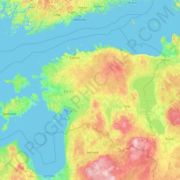
Name: Estonia topographic map, elevation, terrain.
Location: Estonia (57.50933 21.38261 59.93833 28.21002)
Average elevation: 38 m
Minimum elevation: -3 m
Maximum elevation: 270 m
Other topographic maps
Click on a map to view its topography, its elevation and its terrain.
Istanbul
Istanbul, located in northwestern Turkey, is a city that is uniquely situated across two continents, Europe and Asia, divided by the Bosphorus Strait. The city’s topography is characterized by a complex blend of hills, valleys, and coastal plains, which create a varied and scenic landscape. The European side…
Average elevation: 57 m
Croydon
Several apartment developments, for instance Altitude 25 (completed 2010), have been built in recent years, and several more are being built or planned. The construction of Saffron Square, which includes a 43-storey tower, began on Wellesley Road in 2011 and was completed in 2016. Other developments with…
Average elevation: 70 m
Chiang Mai
Chiang Mai has a tropical savanna climate (Köppen Aw), tempered by the low latitude and moderate elevation, with warm to hot weather year-round, though nighttime conditions during the dry season can be cool and much lower than daytime highs. The maximum temperature ever recorded was 42.4 °C (108.3 °F) in…
Average elevation: 424 m
Bangladesh
With an elevation of 1,064 m (3,491 ft), Saka Haphong (also known as Mowdok Mual) near the border with Myanmar, is claimed to be the highest peak of Bangladesh. However, it is not yet widely recognized as the highest point of the country, and most sources give the honor to Keokradong.
Average elevation: 1,488 m
Dehradun
India > Uttarakhand > Dehradun
The city of Dehradun mainly lies in Doon Valley and is at a varying height from 410 m (1,350 ft) in Clement Town to above 700 m (2,300 ft) at Malsi which is 15 km (9.3 mi) from the city. However, the average elevation is 450 m (1,480 ft) above sea level. Malsi is the starting point of Lesser Himalayan Range…
Average elevation: 904 m
Peterborough
United Kingdom > England > Cambridgeshire
The cathedral city of Ely is 24 miles (39 km) east-southeast across the Fens and the university city of Cambridge is 30 miles (48 km) to the southeast. The local topography is flat, and in places, the land lies below sea level.
Average elevation: 17 m
Balfour
Canada > British Columbia > Regional District of Central Kootenay > Area E (Balfour/Cottonwood Lake)
Average elevation: 673 m
Verdin
France > Bourgogne – Franche-Comté > Saône-et-Loire > Montagny-près-Louhans
Average elevation: 199 m
Ben Nevis
United Kingdom > Scotland > Highland
Ben Nevis has a highland tundra climate (ET in the Köppen classification). Ben Nevis's elevation, maritime location and topography frequently lead to cool and cloudy weather conditions, which can pose a danger to ill-equipped walkers. According to the observations carried out at the summit observatory from…
Average elevation: 912 m
Snowdon
United Kingdom > Wales > Gwynedd
Snowdon (/ˈsnoʊdən/), or Yr Wyddfa (Welsh: [ər ˈʊɨ̞̯ðva] ), is a mountain in Snowdonia in North Wales. It has an elevation of 1,085 metres (3,560 ft) above sea level, which makes it both the highest mountain in Wales and the highest in the British Isles south of the Scottish Highlands. Snowdon is…
Average elevation: 692 m
Ανδρούσα
Greece > Peloponnese, Western Greece and the Ionian > Messenia Regional Unit
Average elevation: 96 m
Cairn Gorm
United Kingdom > Scotland > Highland
Cairn Gorm (Scottish Gaelic: An Càrn Gorm) is a mountain in the Scottish Highlands. It is part of the Cairngorms range and wider Grampian Mountains. With a summit elevation of 1,245 m (4,085 ft) above sea level, Cairn Gorm is classed as a Munro and is the sixth-highest mountain in the British Isles. The high,…
Average elevation: 989 m
Vaal Dam
South Africa > Free State > Fezile Dabi District Municipality > Metsimaholo Local Municipality > Deneysville
Average elevation: 1,481 m
Tupungato
Chile > Santiago Metropolitan Region > Provincia de Cordillera > San José de Maipo
Average elevation: 6,002 m
Southampton
United States > Pennsylvania > Bucks County > Upper Southampton Township
Average elevation: 75 m
Guadalajara
Mexico > Jalisco > Guadalajara
Under the Köppen climate classification, Guadalajara has a humid subtropical climate (Cwa), a temperate climate that is quite close to a tropical climate, featuring dry warm winters and wet, mildly hot summers. Guadalajara's climate is influenced by its high altitude and the general seasonality of…
Average elevation: 1,572 m