
Nawada topographic map
Interactive map
Click on the map to display elevation.
About this map
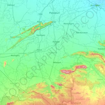
Name: Nawada topographic map, elevation, terrain.
Location: Nawada, Bihar, India (24.52112 85.26755 25.11512 86.05415)
Average elevation: 146 m
Minimum elevation: 42 m
Maximum elevation: 663 m
Other topographic maps
Click on a map to view its topography, its elevation and its terrain.
Patna
India > Bihar > Patna Rural
Patna, Patna Rural, Patna District, Bihar, 800001, India
Average elevation: 51 m
Sultanganj
India > Bihar > Sultanganj
Sultanganj, Bhagalpur District, Bihar, 812006, India
Average elevation: 35 m
Parmanandpur
Parmanandpur, Basantpur, Supaul, Bihar, India
Average elevation: 76 m
Gaya
India > Bihar > Gaya Town C.D.Block
Gaya, Gaya Town C.D.Block, Gaya District, Bihar, 823001, India
Average elevation: 111 m
Baruraj (Motipur)
India > Bihar > Baruraj (Motipur)
Baruraj (Motipur), Muzaffarpur, Bihar, 843132, India
Average elevation: 58 m
Manikpur
India > Bihar > Narpatganj
Manikpur, Narpatganj, Araria, Bihar, 854336, India
Average elevation: 70 m
Sonbhadra Banshi Suryapur
Sonbhadra Banshi Suryapur, Arwal, Bihar, India
Average elevation: 76 m