
Thank you for supporting this site ❤️
Make a donation
Make a donation
Begusarai topographic map
Click on the map to display elevation.
Thank you for supporting this site ❤️
Make a donation
Make a donation
Begusarai
Begusarai is located at 25°25′N 86°08′E / 25.42°N 86.13°E / 25.42; 86.13. It has an average elevation of 41 metres (134 feet). Begusarai lies in North Bihar and is surrounded by Khagaria in the northeast, Munger in the southeast, Patna in the west, and Samastipur in the northwest.
Thank you for supporting this site ❤️
Make a donation
Make a donation
About this map
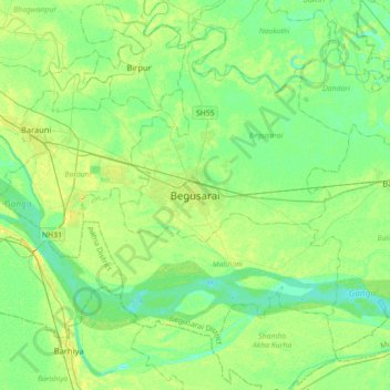
Name: Begusarai topographic map, elevation, terrain.
Location: Begusarai, Bihar, 851117, India (25.25391 85.97488 25.57391 86.29488)
Average elevation: 41 m
Minimum elevation: 32 m
Maximum elevation: 55 m
Thank you for supporting this site ❤️
Make a donation
Make a donation