
Beulah topographic map
Interactive map
Click on the map to display elevation.
About this map
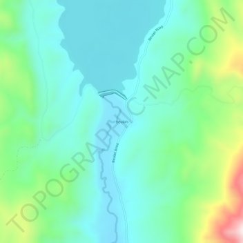
Name: Beulah topographic map, elevation, terrain.
Location: Beulah, Malheur County, Oregon, United States (43.88655 -118.17269 43.92655 -118.13269)
Average elevation: 1,121 m
Minimum elevation: 989 m
Maximum elevation: 1,542 m
Other topographic maps
Click on a map to view its topography, its elevation and its terrain.
Owyhee River
United States > Oregon > Malheur County
Owyhee River, Malheur County, Oregon, United States
Average elevation: 670 m
Snake River
United States > Oregon > Malheur County > Nyssa
Snake River, Nyssa, Malheur County, Oregon, United States
Average elevation: 669 m
Jordan Valley
United States > Oregon > Malheur County
Jordan Valley, Malheur County, Oregon, 97910, United States
Average elevation: 1,354 m
Cairo
United States > Oregon > Malheur County
Cairo, Malheur County, Oregon, United States
Average elevation: 669 m
Vale
United States > Oregon > Malheur County
Vale, Malheur County, Oregon, United States
Average elevation: 710 m
Harper
United States > Oregon > Malheur County
Harper, Malheur County, Oregon, 97906, United States
Average elevation: 781 m
Nyssa
United States > Oregon > Malheur County
Nyssa, Malheur County, Oregon, 97913, United States
Average elevation: 667 m
Rome
United States > Oregon > Malheur County
Rome, Malheur County, Oregon, United States
Average elevation: 1,075 m
Ontario
United States > Oregon > Malheur County
Ontario, Malheur County, Oregon, 97914, United States
Average elevation: 660 m