
Ontario topographic map
Interactive map
Click on the map to display elevation.
About this map
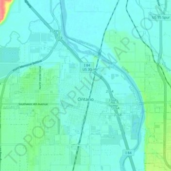
Name: Ontario topographic map, elevation, terrain.
Location: Ontario, Malheur County, Oregon, 97914, United States (44.01022 -117.01989 44.05253 -116.93534)
Average elevation: 660 m
Minimum elevation: 649 m
Maximum elevation: 714 m
Ontario is located at an elevation of 2,150 feet (660 m) above sea level.
Other topographic maps
Click on a map to view its topography, its elevation and its terrain.
Owyhee River
United States > Oregon > Malheur County
Owyhee River, Malheur County, Oregon, United States
Average elevation: 670 m
Beulah
United States > Oregon > Malheur County
Beulah, Malheur County, Oregon, United States
Average elevation: 1,121 m
Snake River
United States > Oregon > Malheur County > Nyssa
Snake River, Nyssa, Malheur County, Oregon, United States
Average elevation: 669 m
Jordan Valley
United States > Oregon > Malheur County
Jordan Valley, Malheur County, Oregon, 97910, United States
Average elevation: 1,354 m
Cairo
United States > Oregon > Malheur County
Cairo, Malheur County, Oregon, United States
Average elevation: 669 m
Vale
United States > Oregon > Malheur County
Vale, Malheur County, Oregon, United States
Average elevation: 710 m
Harper
United States > Oregon > Malheur County
Harper, Malheur County, Oregon, 97906, United States
Average elevation: 781 m
Nyssa
United States > Oregon > Malheur County
Nyssa, Malheur County, Oregon, 97913, United States
Average elevation: 667 m
Rome
United States > Oregon > Malheur County
Rome, Malheur County, Oregon, United States
Average elevation: 1,075 m