
合肥经济技术开发区 topographic map
Interactive map
Click on the map to display elevation.
About this map
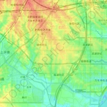
Name: 合肥经济技术开发区 topographic map, elevation, terrain.
Location: 合肥经济技术开发区, 蜀山区, 合肥市, 安徽省, 中国 (31.67551 117.16754 31.80314 117.27583)
Average elevation: 22 m
Minimum elevation: 4 m
Maximum elevation: 48 m
Other topographic maps
Click on a map to view its topography, its elevation and its terrain.