
Aral Sea topographic map
Interactive map
Click on the map to display elevation.
About this map
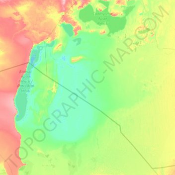
Name: Aral Sea topographic map, elevation, terrain.
Location: Aral Sea, Kazakhstan (43.37511 58.19858 46.78424 61.66442)
Average elevation: 69 m
Minimum elevation: 26 m
Maximum elevation: 320 m
Other topographic maps
Click on a map to view its topography, its elevation and its terrain.
Astana
Astana is located in central Kazakhstan on the Ishim River in a very flat, semi-arid steppe region which covers most of the country's territory. It is at 51° 10' north latitude and 71° 26' east longitude. The city encompasses 722.0 square kilometres (278.8 sq mi). The elevation of Astana is 347 metres (1,138…
Average elevation: 361 m
Baikonur
The Soviet government established the Nauchno-Issledovatel'skii Ispytatel'nyi Poligon N.5 (NIIIP-5), or Scientific-Research Test Range N.5 by its decree of 12 February 1955. The U-2 high-altitude reconnaissance plane found and photographed the Tyuratam missile test range (cosmodrome Baikonur) for the first…
Average elevation: 100 m
Almaty
Almaty is still the major commercial, financial, and cultural centre of Kazakhstan, as well as its most populous and most cosmopolitan city. The city is located in the mountainous area of southern Kazakhstan near the border with Kyrgyzstan in the foothills of the Trans-Ili Alatau at an elevation of 700–900 m…
Average elevation: 1,474 m
Kokshetau
It was the administrative center of Kokshetau Region (oblast) from 1944 to 1991 as part of the Soviet Union and from 1991 as part of Kazakhstan to 1997 when it was abolished. It is also situated at the junction of the Trans-Kazakhstan and South Siberian railways. Kokshetau lies at an elevation of approximately…
Average elevation: 261 m
Atakent
Kazakhstan > Turkistan Region > Maqtaaral District > Ильич кенттік әкімдігі
Average elevation: 263 m