
Kyzylorda Region topographic map
Interactive map
Click on the map to display elevation.
About this map
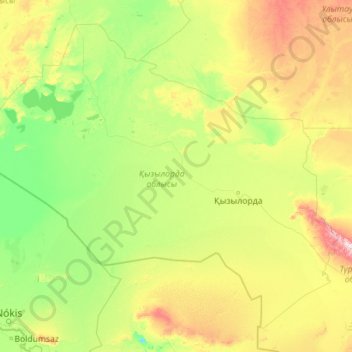
Name: Kyzylorda Region topographic map, elevation, terrain.
Location: Kyzylorda Region, Kazakhstan (42.32271 59.03060 47.82773 68.06030)
Average elevation: 153 m
Minimum elevation: 6 m
Maximum elevation: 1,512 m
Other topographic maps
Click on a map to view its topography, its elevation and its terrain.
Baikonur
The Soviet government established the Nauchno-Issledovatel'skii Ispytatel'nyi Poligon N.5 (NIIIP-5), or Scientific-Research Test Range N.5 by its decree of 12 February 1955. The U-2 high-altitude reconnaissance plane found and photographed the Tyuratam missile test range (cosmodrome Baikonur) for the first…
Average elevation: 100 m
Atakent
Kazakhstan > Turkistan Region > Maqtaaral District > Ильич кенттік әкімдігі
Average elevation: 263 m