
漩坪乡 topographic map
Interactive map
Click on the map to display elevation.
About this map
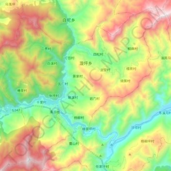
Name: 漩坪乡 topographic map, elevation, terrain.
Location: 漩坪乡, 北川羌族自治县, 绵阳市, 四川省, 中国 (31.81854 104.33701 31.95373 104.51234)
Average elevation: 1,306 m
Minimum elevation: 607 m
Maximum elevation: 2,326 m
2008年5月12日發生四川大地震當日,當地形成的唐家山堰塞湖將整個漩坪鄉淹沒,鄉政府、小學、等全被淹沒
Other topographic maps
Click on a map to view its topography, its elevation and its terrain.