
桃龙藏族乡 topographic map
Interactive map
Click on the map to display elevation.
About this map
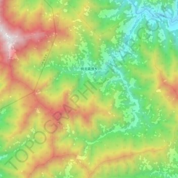
Name: 桃龙藏族乡 topographic map, elevation, terrain.
Location: 桃龙藏族乡, 北川羌族自治县, 绵阳市, 四川省, 中国 (31.92955 104.08677 32.02460 104.20350)
Average elevation: 1,693 m
Minimum elevation: 857 m
Maximum elevation: 2,851 m
Other topographic maps
Click on a map to view its topography, its elevation and its terrain.