
Çankırı topographic map
Interactive map
Click on the map to display elevation.
Çankırı
Çankırı has a dry summer continental climate (Köppen climate classification Dsa and Dsb) with humid continental climate (Dfa and Dfb) characteristics, since the wettest part of the year is spring and early summer. The province displays all four of these continental climate subtypes depending on location and elevation. The city is located in a transitional region of the province. Summers are usually hot and dry and winters are cold and snowy.
About this map
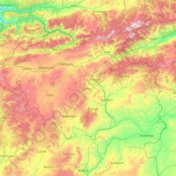
Name: Çankırı topographic map, elevation, terrain.
Location: Çankırı, Central Anatolia Region, Turkey (40.24933 32.56743 41.09713 34.16569)
Average elevation: 1,134 m
Minimum elevation: 290 m
Maximum elevation: 2,542 m
Other topographic maps
Click on a map to view its topography, its elevation and its terrain.
Gaziantep
The plan introduced several important changes to the city's transportation network. One of the most important was the addition of a rail line to connect Gaziantep to the national rail system. Up to now, Turkish railway construction had ignored Gaziantep (partly because of its mountainous surroundings); a…
Average elevation: 880 m
Ayder
Ayder at 40°57′N 41°05′E / 40.950°N 41.083°E / 40.950; 41.083 is a typical yayla with no settled population; it hosts visitors during summers. The average altitude is 1,350 metres (4,430 ft). It is a part of Çamlıhemşin District of Rize Province. The distance to Çamlıhemşin is 17…
Average elevation: 1,683 m
Mount Erciyes
The climate of the region is influenced by topography, with the Taurus and Kaçkar Mountains blocking the entry of moisture into Anatolia. Summers are dry and hot and winters wet and cold; in Kayseri, summer temperatures are about 19 °C (66 °F) and winter temperature about 0 °C (32 °F). Precipitation at…
Average elevation: 3,329 m
Marash
Turkey > Dulkadiroğlu > Dulkadiroğlu
At 2,300 m (7,500 ft) elevation, the nearby Yedikuyular Ski Resort offers winter sports activities.[25]
Average elevation: 843 m
Hacıbektaş
Turkey > Hacıbektaş > Hacıbektaş
Hacıbektaş, formerly Karahöyük, is a town and district of Nevşehir Province in the Central Anatolia region of Turkey. According to 2000 census, population of the district is 11,929 of which 5,169 live in the town of Hacıbektaş. Located in Cappadocia, the district covers an area of 697 km2 (269 sq mi),…
Average elevation: 1,269 m
Adana
Adana is located on the 37th parallel north on the northeastern edge of the Mediterranean, where it serves as the gateway to the Cilician plain. This large stretch of flat, fertile land lies southeast of the Taurus Mountains. Heading west across Cilicia from Adana, the road from Tarsus enters the foothills of…
Average elevation: 61 m