
Thailand topographic map
Interactive map
Click on the map to display elevation.
Thailand
Thailand comprises several distinct geographic regions, partly corresponding to the provincial groups. The north of the country is the mountainous area of the Thai highlands, with the highest point being Doi Inthanon in the Thanon Thong Chai Range at 2,565 metres (8,415 ft) elevation. The northeast, Isan, consists of the Khorat Plateau, bordered to the east by the Mekong River. The centre of the country is dominated by the predominantly flat Chao Phraya river valley, which runs into the Gulf of Thailand.
About this map
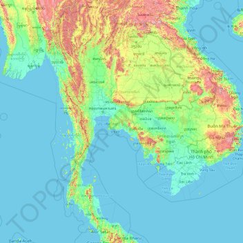
Name: Thailand topographic map, elevation, terrain.
Location: Thailand (5.61285 97.34381 20.46483 105.63681)
Average elevation: 156 m
Minimum elevation: -3 m
Maximum elevation: 2,557 m
Other topographic maps
Click on a map to view its topography, its elevation and its terrain.
Chiang Mai
Chiang Mai has a tropical savanna climate (Köppen Aw), tempered by the low latitude and moderate elevation, with warm to hot weather year-round, though nighttime conditions during the dry season can be cool and much lower than daytime highs. The maximum temperature ever recorded was 42.4 °C (108.3 °F) in…
Average elevation: 424 m
Ban Ton Pho
Thailand > Pathum Thani Province > Mueang Pathum Thani District > Bang Khayaeng Subdistrict
Average elevation: 4 m
Mae Salong
Thailand > Chiang Rai Province > Mae Fa Luang district
Santikhiri is a hilltop village in the Mae Fa Luang district of Thailand's Chiang Rai Province, about 80 kilometres (50 mi) from Chiang Rai. Santikhiri is on the highest peak of the Doi Mae Salong range of mountains, at an elevation of 1,134 metres (3,722 ft) above sea level. It has an alpine-like climate,…
Average elevation: 1,035 m
Doi Suthep
Doi Suthep (ดอยสุเทพ), is a mountain ("doi") west of Chiang Mai, Thailand. It is 1,676 metres (5,499 ft) in elevation and is one of the twin peaks of a granite mountain. The other peak is known as Doi Pui and is slightly higher (1,685 metres (5,528 ft)).
Average elevation: 1,351 m
Bangkok
Bangkok is in the Chao Phraya River delta in Thailand's central plain. The river meanders through the city in a southerly direction, emptying into the Gulf of Thailand approximately 25 kilometres (16 mi) south of city centre. The area is flat and low-lying, with an average elevation of 1.5 metres (4 ft 11 in)…
Average elevation: 4 m
Ban Don Chuen Mu 4
Thailand > Chiang Mai Province > Saraphi District > Nong Phueng > Ban Don Chuen Mu 4
Average elevation: 300 m