
金溪县 topographic map
Interactive map
Click on the map to display elevation.
About this map
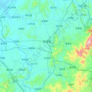
Name: 金溪县 topographic map, elevation, terrain.
Location: 金溪县, 抚州市, 江西省, 中国 (27.68278 116.45731 28.10404 117.04686)
Average elevation: 155 m
Minimum elevation: 32 m
Maximum elevation: 1,344 m
金溪位于鄱阳湖平原与武夷山交界处,地势东南高西北低。最高峰出云峰,海拔1233米。
Other topographic maps
Click on a map to view its topography, its elevation and its terrain.
【贛江三角洲濕地(贛江圍閭)】(南昌市新建區南磯鄉屬地並管理)
【贛江三角洲濕地(贛江圍閭)】(南昌市新建區南磯鄉屬地並管理), 都昌镇, 新建区, 南昌市, 江西省, 中国
Average elevation: 11 m