
永修县 topographic map
Interactive map
Click on the map to display elevation.
About this map
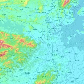
Name: 永修县 topographic map, elevation, terrain.
Location: 永修县, 九江市, 江西省, 中国 (28.89622 115.37899 29.35560 116.24892)
Average elevation: 110 m
Minimum elevation: 8 m
Maximum elevation: 1,482 m
Other topographic maps
Click on a map to view its topography, its elevation and its terrain.
【贛江三角洲濕地(贛江圍閭)】(南昌市新建區南磯鄉屬地並管理)
【贛江三角洲濕地(贛江圍閭)】(南昌市新建區南磯鄉屬地並管理), 都昌镇, 新建区, 南昌市, 江西省, 中国
Average elevation: 11 m