
黎川县 topographic map
Interactive map
Click on the map to display elevation.
About this map
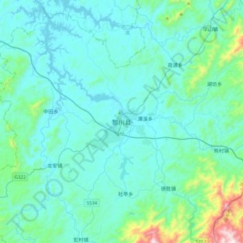
Name: 黎川县 topographic map, elevation, terrain.
Location: 黎川县, 日峰镇, 黎川县, 抚州市, 江西省, 中国 (27.12463 116.74239 27.44463 117.06239)
Average elevation: 217 m
Minimum elevation: 89 m
Maximum elevation: 1,194 m
全县以山地为主。东部为武夷山脉,高峰如杨家岭海拔1513米,会仙峰海拔1355米、大山嵊海拔1212米,太平嵊海拔1071米。通过叶竹隘(207省道),沙塘隘(京福高速公路)与福建省相通。