
元谋县 topographic map
Interactive map
Click on the map to display elevation.
About this map
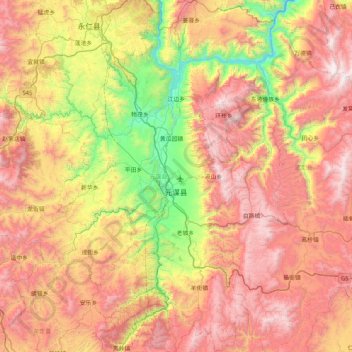
Name: 元谋县 topographic map, elevation, terrain.
Location: 元谋县, 楚雄彝族自治州, 云南省, 中国 (25.36702 101.59382 26.11326 102.10687)
Average elevation: 1,845 m
Minimum elevation: 895 m
Maximum elevation: 2,862 m
元谋地处滇中高原北部,地势呈四周高,中间低,由南向北倾斜的“筲箕凹”形。境内最低海拔898米,最高海拔2,835.9米,全县面积的40%处于海拔1,350米以下的干热河谷区。热区面积达797.07平方公里,分布在7乡3镇。热区内干旱少雨,年均降雨量仅为642毫米,年蒸发量高达3,627毫米,年平均气温21.5摄氏度,四季不分明,全年基本无霜。1983年12月28日和2022年2月21日,當地兩次降雪,期間沒有任何降雪。
Other topographic maps
Click on a map to view its topography, its elevation and its terrain.
西双版纳热带植物园-百竹园
西双版纳热带植物园-百竹园, 勐仑镇, 勐腊县, 西双版纳傣族自治州, 云南省, 666100, 中国
Average elevation: 559 m